
Area 292 km² Local time Thursday 1:25 PM | Website www.city.gojo.lg.jp Population 35,380 (31 May 2011) Flower Platycodon | |
 | ||
Time zone Japan Standard Time (UTC+9) City hall address 1-1-1 Honmachi, Gojō-shi, Nara-ken637-8501 Weather 9°C, Wind NW at 14 km/h, 65% Humidity | ||
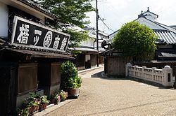
Gojō (五條市, Gojō-shi) is a city located in Nara Prefecture, Japan. The city was founded on October 15, 1957.
Contents
Map of Gojo, Nara Prefecture, Japan
As of September 30, 2014, the city has an estimated population of 33,283, with 13,742 households. It has a population density of 121.17 persons per km². The total area is 291.98 km².
On September 25, 2005, the villages of Nishiyoshino and Ōtō (both from Yoshino District) were merged into Gojō.
Geography
Located in western Nara Prefecture, the Yoshino River flows through the city. It is surrounded mostly by mountains, although the city hall is located in a flat basin. Situated north of the city hall is Mount Kongō, at 1125 m. Persimmon is a major fruit crop in Gojō.
Neighboring municipalities
Education
Rail
Roads
References
Gojō, Nara Wikipedia(Text) CC BY-SA