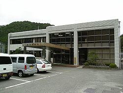
Area 47.71 km² Local time Sunday 2:27 PM | Population 1,114 (2003) | |
 | ||
Time zone Japan Standard Time (UTC+9) Website www.vill.kurotaki.nara.jp Weather 13°C, Wind W at 11 km/h, 53% Humidity | ||
Kurotaki (黒滝村, Kurotaki-mura) is a village located in Yoshino District, Nara Prefecture, Japan.
Contents
- Map of Kurotaki Yoshino District Nara Prefecture Japan
- Geography
- Surrounding municipalities
- History
- References
Map of Kurotaki, Yoshino District, Nara Prefecture, Japan
As of 2003, the village has an estimated population of 1,114 and a density of 23.35 persons per km². The total area is 47.71 km².
Geography
Located north of Mount Yoshino, it is part of the municipalities in the Kii Mountain Range.
Surrounding municipalities
History
References
Kurotaki, Nara Wikipedia(Text) CC BY-SA
