
Location County Wicklow Number of drops 3 | Province Leinster | |
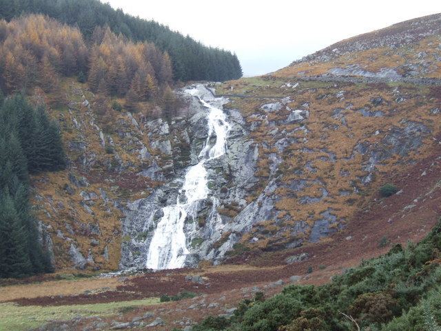 | ||
Elevation 350 ± 10 metres (1,148 ± 33 ft) Total height 80 ± 10 metres (262 ± 33 ft) Address Carrigeenduff, Laragh, Co. Wicklow, Ireland Similar Lough Tay, Tonelagee, Powerscourt Waterfall, Wicklow Way, Wicklow Mountains | ||
Glenmacnass waterfall wicklow
The Glenmacnass Waterfall (Irish: Gleann Log an Easa, meaning "The glen of the hollow of the waterfall") is a waterfall on the Glenmacnass River and constitutes the beginning of the Glenmacnass valley. The valley ends near the village of Laragh in County Wicklow and can be easily traversed by the Military Road joining Sally Gap to Laragh.
Contents
- Glenmacnass waterfall wicklow
- Wicklow mountains glenmacnass waterfall
- River and waterfall
- Valley
- References
Wicklow mountains glenmacnass waterfall
River and waterfall
The river begins high up on the south east quadrant of Mullaghcleevaun mountain, the second tallest of the Wicklow Mountains at 849 metres (2,785 ft), then flows down the surrounding mountains to the waterfall top at 350 ± 10 metres (1,148 ± 33 ft). The waterfall consists of 3 staggered drops down to 270 ± 10 metres (886 ± 33 ft).
It continues through the valley and joins the river Avonmore (Irish: Abhainn Mór, meaning "big river") at Laragh. It is later joined by the river Avonbeg (Irish: Abhainn Beag, meaning "small river") to become the river Avoca and eventually flows into the Irish Sea at the coastal town called Arklow.
Valley
The valley was carved out during the last glacial period called the quaternary glaciation or Ice Age, which dates from 2.58 Ma (million years ago) to present. The Military Road joining Sally Gap to Laragh passes through the valley running parallel to the river.