
Website www.gijang.go.kr Local time Tuesday 6:53 AM | Administrative divisions 2 eup, 3 myeon Area 217.9 km² Population 146,260 (31 Dec 2013) | |
 | ||
Weather 5°C, Wind N at 6 km/h, 74% Humidity Points of interest Haedong Yonggungsa, Waeseong in Jukseong-ri, Gijang, Baseball Lighthouse | ||
Gijang County is a gun, or county, located between Haeundae-gu and Ulsan in northern Busan, South Korea.
Contents
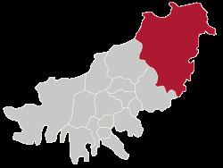
- Map of Gijang gun Busan South Korea
- History
- Geography and demographics
- Economy
- Education
- Tourism
- Administrative divisions
- References
Map of Gijang-gun, Busan, South Korea
History
Gijang first appears under its current name in the annals of the year 757, during the Unified Silla period. At that time it was made the hyeon of Gijang, part of Dongnae-gun. The Samguk Sagi records that it was known as Gaphwayanggok (甲火良谷) previously.
Historical landmarks in the county include the Buddhist temple of Jangansa, said to have been first built by Wonhyo in the 7th century.
Geography and demographics
Gijang is the most rural of Busan's districts, and consists mostly of vacant and agricultural land. Approximately 156.7 of its 217.9 square kilometers are empty and forested, mostly hilly land. The county's population has risen steadily since 1990, when it stood at 56,847. There is a fishing village set along the coastline.
Economy
Due to its location along the coast of the East Sea of Korea, Gijang is known as a center for the production of various kinds of seafood. These include anchovies and brown seaweed (miyeok).
Education
Gijang is also the current residence of the new Busan International Foreign School, which the Ministry of Education recently spent 46.9 Billion won.
Tourism
Other points of interest in the Gijang area include Toam Pottery Park and Ilgwang Beach, as well as the cliffside Haedong Yonggungsa temple. The fishing village is popular for its fresh seafood and sashimi.
Administrative divisions
Gijang is divided into five parts: