
State/Province DE-BY First ascent by locals Mountain range Allgäu Alps | Parent range Allgäu Alps Elevation 1,949 m | |
 | ||
Similar | ||
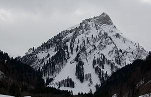
The Giebel is the northeastern corner of the mountain chain that branches off to the northeast at the Laufbacher Eck. It has a height of 1,949 metres and belongs to the Allgäu grass mountains. Northeast of the Giebel lies the Alpine hut of Giebelhaus, which may be reached on a road from Hinterstein that is not open to the public. From the Giebel there are impressive views down to the Giebelhaus.
Contents
Map of Giebel, 87541 Bad Hindelang, Germany
No waymarked path leads to the Giebel. It may be ascended, however, from the Feldalpe on trackless terrain. This climb requires a head for heights and sure-footedness. A crossing of the entire ridge from the Giebel via the Berggächtle and the Salober to the Laufbacher Eck is occasionally attempted by experienced mountain climbers (climbing grade UIAA III).
The botany of the Giebel is similar to that of the more famous Höfats or Schneck.