
First ascent 1848 by O. Sendtner Prominence 478 m | Elevation 2,259 m | |
 | ||
Mountain type Aptychen and Hornstein limestone on a base of lias flecked marl (Fleckenmergel)Allgäuer Grasberg Similar Großer Wilder, Schneck, Trettachspitze, Mädelegabel, Rauheck | ||
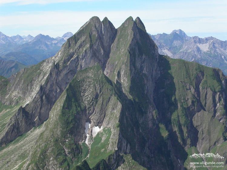
The Höfats is a 2,259 m high mountain in the Allgäu Alps. Located near Oberstdorf, it separates the Oy and the Dietersbach valleys, along with the Rauheck and other lower summits. With its very steep faces it is the most striking of the Allgau "grass mountains" (Grasberge) and is unique in the Eastern Alps. It may be compared to the mountains of the Lofoten.
Contents
Map of H%C3%B6fats, 87561 Oberstdorf, Germany
Location and surrounding areaEdit
The Höfats has four almost equally high and narrow summits, whose appearance has been said in the past to resemble that of a Gothic cathedral.
The four summits of the Höfats divide into two pairs of peaks that are separated by the Höfats wind gap (Höfatsscharte, 2207 m). Between the summits of the two pairs of peaks are smaller gaps (about 2233 m and 2227 m high). All of the peaks sit on the crest of a ridge that runs from Rauheck towards the northwest.
From the eastern summit (Ostgipfel) (2259 m) a ridge runs towards the southeast to a saddle, the Älpelesattel, and a ledge heads east-southeast, the centre of which has an overhang (the Höfatszahn). Between the ridge and the edge is the southeast face of the eastern summit. In addition, a slight ridge runs from the eastern summit to the southwest, which separates the ravine of Bergangertobel in the east from the Höfats basin (Höfatswanne) in the west.
The next summit is the central one (Mittelgipfel, 2257 m) which is actually only a 20 m long, horizontal edge, which apart from the two main ridges, only has a ridge descending to the southwest that ends in the Höfatswanne as a pillar. At the foot of this ridge is a cave (Höfatsgufel or Gufel). On the eastern side of the central peak, there is no corresponding ridge; instead the face drops several hundred metres, partially overhanging, into the Rotes Loch.
The longest ridge in the vicinity of the Höfats, runs northeast from the next peak after the Höfatsscharte wind gap, the second summit or Zweiter Gipfel (2258.8 m). Initially, this drops off steeply down to the wind gap (Schärtele) between Höfats and Kleine Höfats and continues as the northeastern ridge of the Kleine Höfats. The north face of the second peak drops vertically in places down to the Rauher Hals. Beneath the foot of the rock face is a prominent rock pinnacle, the Höfatsnadel.
The western peak (Westgipfel, 2257.7 m) is connected to the second peak by a less pronounced wind gap. The north ridge (Nordgrat) runs northwards from the west summit, which drops steeply to the Rauhenhalsgrat. The ridge heading southwest and topped with small rock towers, borders the western side of the Höfatswanne.