
Peak Nagy-Gerecse Type of rock Chalk | Elevation 634 m (2,080 ft) Area 850 km² | |
 | ||
County | ||
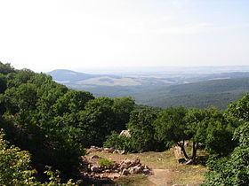
Gerecse is a mountain range in north-western Hungary, in the Central Transdanubian region, between the ranges Vértes and Pilis and part of the Komárom-Esztergom County. A low limestone mountain situated between the town of Tatabánya and the Danube River. The Gerecse Mountains are part of the Transdanubian Mountains. Gerecse occupies an area of 850 km2 (20,300 ha). The highest point is Nagy-Gerecse at 634 m. The main rock is chalk and limestone.
Map of S%C3%BCtt%C5%91, Gerecse, 2543 Hungary
Deciduous oak Quercus forests cover the lower slopes, with submontane forests of Quercus, Carpinus, Fagus, and karst scrub at higher altitudes. The area is 70% forest, 5% scrubland, 10% grassland, and 15% artificial landscapes. Yearly sunshine duration is around 1,980 hours. The average annual temperature above the height of 350 meters is 9.5 C (in January -2,8 C). The average annual precipitation is 640 millimeters.