
Length 556.8 km | ||
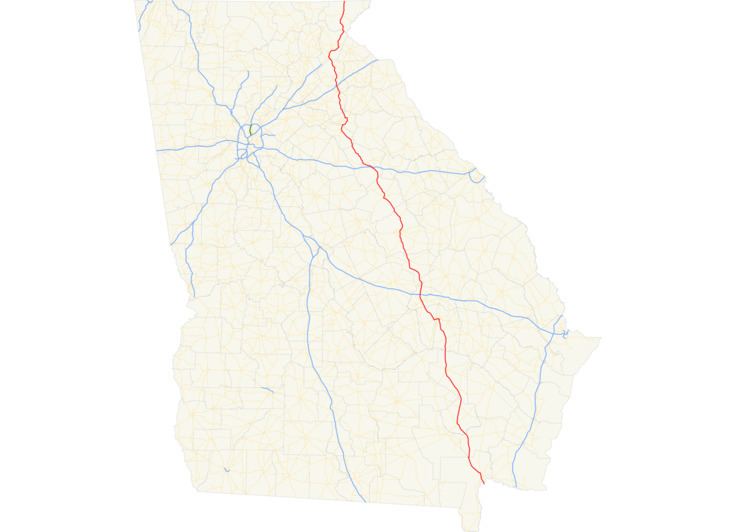 | ||
South end: US 1 / US 23 / US 301 / SR 15 and SR 4 at Florida state line near Folkston North end: US 23 / US 441 at the North Carolina state line in Dillard Counties Charlton County, Georgia, Brantley County, Georgia | ||
State Route 15 (SR 15) is a 346-mile-long (557 km) state highway that travels south-to-north across the entire length of the U.S. state of Georgia, east of its centerline. It connects the Florida state line, south-southeast of Folkston with the North Carolina state line, in Dillard, via Folkston, Vidalia, Sandersville, Athens, Demorest, and Clayton.
Contents
- Map of GA 15 Georgia USA
- Route description
- History
- AthensCommerce alternate route
- Cornelia connector route
- Tallulah Falls scenic loop
- References
Map of GA-15, Georgia, USA
Route description
SR 15 enters Georgia just south of Folkston as a four-lane highway, along with US 1, US 23, US 301, and SR 4. In Homeland, US 301 branches off to the north while the other four routes plus SR 121, head northwest. After about 10 miles (16 km), SR 15 and SR 121 also branch off from US 1/US 23/SR 4, as a two-lane highway, crossing US 82/SR 520 (South Georgia Parkway) in Hoboken. The two state routes continue northwest through Blackshear, where they cross US 84/SR 38. After that, the two state routes continue to stay together, heading north through the community of Bristol. Soon after, SR 121 branches off to the north while SR 15 heads northwest to rejoin US 1 and SR 4 at Baxley. North of Baxley, the three highways continue, remaining a four-lane highway all the way to the Altamaha River. Approximately 10 miles (16 km) past the river crossing, SR 15 branches off to the northwest again, where SR 29 begins and follows SR 15. At Vidalia, SR 15 and SR 29 turn west and follow US 280/SR 30 for several miles to the community of Higgston. The two highways head north from there through the community of Tarrytown and then on to Soperton. SR 29 heads northwest of Soperton while SR 15, along with SR 78, continues north, reaching an interchange with I-16, and goes to Adrian. The two state routes continue northwest to Wrightsville, where SR 78 departs eastward. SR 15 continues by itself through the adjacent cities of Tennille and Sandersville. Through these cites, most of SR 15 has been widened to four lanes, and it briefly picks up SR 24. North of Sandersville, SR 15 crosses the Fall Line Freeway and then heads north through the community of Warthen and onto Sparta. Through Sparta, SR 15 makes a few turns, briefly picking up SR 16 and SR 22. North of Sparta, it picks up SR 77, and continues north through White Plains and Siloam. At Siloam, SR 15 has an interchange with I-20. SR 77 departs to the north while SR 15 continues northwest to Greensboro, passing beneath I-20, but without direct access. In Greensboro, SR 15 makes two more turns, briefly following US 278/SR 12 through downtown. SR 15 continues northwest to Watkinsville, after which it joins US 129/US 441. It travels together with US 441 as a mostly four-lane highway throughout the rest of their course in Georgia.
The three highways, along with several others, circle around the east side of Athens along the SR 10 Loop (Athens Perimeter Highway) and head north through the town of Nicholson and around the east side of Commerce via a bypass. The highways then have an interchange with I-85, and head between the towns of Baldwin and Cornelia, where they become a limited access freeway for a short time and rejoin US 23. The three highways remain together and head through the cities of Tallulah Falls, Clayton, and Dillard before crossing into North Carolina.
The entire length of SR 15 is included as part of the National Highway System, a system of roadways important to the nation's economy, defense, and mobility.
History
In Athens, SR 15 has followed several routes prior to its current alignment with SR 10 Loop. It originally was aligned with US 129 along Milledge and Prince Avenue to make its way to Jefferson. SR 24 was paired with US 441 along the current route of SR 15 between Athens and Commerce. It followed this route until both US 441 and US 129 were paired with SR 10 Loop, but had an alternate routing along Lumpkin Street and what is now Dr. Martin Luther King Jr. Parkway. When the main route was shifted to the bypass, this alternate route took the place of the original, eventually pairing with US 129 to Jefferson, while the main route now replaced SR 24 along US 441 from Watkinsville to Commerce.
Athens–Commerce alternate route
State Route 15 Alternate (SR 15 Alt.) is a 31.7-mile long (51.0 km) alternate route of SR 15. It consists of a series of streets, roads, and highways that form a south-to-north-oriented highway in Clarke and Jackson counties in the northeastern part of the U.S. state of Georgia. SR 15 Alt.'s southern terminus is in Athens at the interchange of Milledge Avenue and US 29/US 78/US 129/US 441/SR 8/SR 10 Loop/SR 15 (Athens Perimeter Highway) and Macon Highway. The segment along Milledge Avenue winds by the campus of the University of Georgia. This street features stately homes and mansions, some of which house college fraternities and sororities. SR 15 Alt. follows Prince Avenue northwest after the northern end of Milledge Avenue. As SR 15 Alt. leaves Athens, it becomes concurrent with US 129, where it is known as Jefferson Road. Upon entering Jefferson, SR 15 Alt. splits from US 129 and becomes an independent route. Its northern terminus is north of the city of Commerce at its intersection with US 441 (sometimes referred to as the Commerce Bypass) and SR 59.
Cornelia connector route
State Route 15 Connector (SR 15 Conn.) is a 0.7-mile-long (1.1 km) connector route that exists entirely within Cornelia. It is known locally as Level Grove Road, and is designed to facilitate northbound to southbound traffic between US 23/SR 365 and US 441/SR 15. North of US 23 and south of US 441, the highway is unmarked.
The entire route is in Cornelia, Habersham County.
Tallulah Falls scenic loop
State Route 15 Loop (SR 15 Loop) is a former segment of US 23/US 441/SR 15 used as a scenic overlook for Tallulah Falls. It is essentially a loop off of the three highways to the overlook.