
Existed: August 1932 – present Constructed August 1932 | Length 35.9 km | |
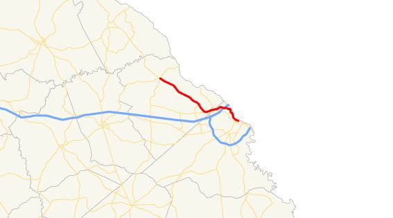 | ||
West end: US 221 / SR 47 / SR 150 in Pollards Corner | ||
State Route 104 (SR 104) is a 22.3-mile-long (35.9 km) state highway in the east-central part of the U.S. state of Georgia. Most of its eastern portion is an urban corridor in the Augusta metropolitan area. It travels within portions of Columbia and Richmond counties. It is known as Washington Road from its western terminus to the Columbia–Richmond county line. On both sides of the county line, it is known as Pleasant Home Road. It is known as Riverwatch Parkway from just west of the county line to the northern part of downtown Augusta. In downtown, it is known as part of Jones Street and Reynolds Street.
Contents
Map of GA-104, Georgia, USA
Route description
SR 104 begins at an intersection with U.S. Route 221 (US 221), SR 47, and SR 150 in Pollards Corner. It travels to the southeast and crosses over Kiokee Creek on the Robert W. Pollard Bridge. Just over 1.5 miles (2.4 km) later, it crosses over Little Kiokee Creek on the B. Edward Tankersley Memorial Bridge. Slightly more than 2 miles (3.2 km) after that, they cross over Euchee Creek on the G.B. "Dip" Lamkin Bridge. Just before entering Evans, the highway transitions into a retail corridor. In town, they travel southwest of Evans Towne Center Park and intersect the northern terminus of SR 383 (North Belair Road). SR 104 curves to the south-southeast and intersects both the eastern terminus of Towne Centre Drive and the western terminus of Riverwatch Parkway that has been extended to this intersection. It then curves to the east and intersects SR 232 (Columbia Road) on the Evans–Martinez city line. SR 104/SR 232 travel concurrently for approximately 0.2 miles (0.32 km). At an intersection with Old Evans Road, SR 232 splits off to the south onto Bobby Jones Expressway. After curving to the east-southeast, SR 104 enters Richmond County and the city limits of Augusta.
Immediately after entering the county, SR 104 intersects the western terminus of SR 104 Connector, which takes the Washington Road name. The mainline route turns left onto Pleasant Home Road, briefly re-enters Columbia County, and immediately turns right onto River Watch Parkway. Less than 500 feet (150 m) after that turn, it re-enters Richmond County. Approximately 0.5 miles (0.80 km) later, it intersects SR 28 (Furys Ferry Road). The roadway travels to the northeast and curves back to the southeast, to an interchange with Interstate 20 (I-20; Carl Sanders Highway). SR 104 curves to a more east-southeasterly direction. After curving around the eastern side of Eisenhower Park, the highway begins paralleling the Savannah River, before it crosses over the Augusta Canal on the William "Billy" L. Powell, Jr. Bridge. The highway has an interchange that leads to downtown Augusta and the Medical District. About 1,500 feet (460 m) later is another crossing of the canal, this time on a nameless bridge. Four blocks later, the highway meets its eastern terminus, an intersection with US 25 Business/SR 4 (13th street). Here, the roadway continues as Jones and Reynolds streets, while traveling on one-way streets.
All of SR 104 is included as part of the National Highway System, a system of roadways important to the nation's economy, defense, and mobility.
History
The road that would eventually become SR 104 was established by the middle of 1930 as SR 52 just east of the Columbia–Richmond county line. By the third quarter of 1932, SR 52 was redesignated as SR 104 and was extended northwest to Phinizy. This extension was unimproved, but maintained. By the end of 1934, a small segment was under construction northwest of the county line. By the end of the next year, a segment of the highway, farther to the northwest had completed grading, but was not surfaced. A year later, the under construction segment had completed grading, but was not surfaced. It was under construction for the rest of its length. By the end of the year, the highway had a completed hard surface from about Evans to the SR 52 intersection in Martinez. A few months later, it had a completed hard surface segment just northwest of Evans. In early 1940, it had completed grading, but was not surfaced from Phinizy to just northwest of Evans. By the end of the year, it had a sand clay or top soil surface from Phinizy to just northwest of Evans. About five years later, SR 104 had a completed hard surface from just southeast of Pollards Corner to just northwest of Evans. By the end of 1946, it was hard surfaced from Leah to just southeast of that community. By March 1948, it was hard surfaced from Pollards Corner to just southeast of that community. Before the end of the first quarter of 1949, the highway was hard surfaced from Leah to Pollards Corner. By 1988, the Leah-to-Pollards Corner segment was redesignated as SR 47, due to that highway being shifted to the east.
Riverwatch Parkway was originally constructed in the late 1980s and early 1990s to relieve heavy rush-hour traffic on congested Washington Road and John C. Calhoun Expressway, which many Augusta area residents used (and continue to use) to travel to and from work.
Future
In future plans, Old Petersburg Road will be widened all the way to its intersection with Old Evans Road in Martinez, Georgia. Then a new road will be constructed to continue the path to the town center of Evans in Columbia County. The goal of this project is to make driving easier, safer, and faster from the ever-expanding westward population migration to and from downtown Augusta.
Augusta connector route
State Route 104 Connector (SR 104 Conn.) is a 0.6-mile-long (0.97 km) connector route that exists entirely within the northern part of Richmond County. Its entire route is within the city limits of Augusta. It is known as Washington Road for its entire length.
It begins just east of the Columbia-Richmond county line, at an intersection with the SR 104 mainline (Washington Road/Pleasant Home Road). The highway travels east-southeast until it meets its eastern terminus, an intersection with SR 28 (Furys Ferry Road/Washington Road).
All of SR 104 Connector is included as part of the National Highway System.
The entire route is in Augusta, Richmond County.