
Continent — Area Ranked 205th | Coordinates 19°30'N, 80°30'W Coastline 160 km (99 mi) | |
 | ||
Region Central AmericaCaribbean Sea Borders Total land borders:0 km (0 miles) | ||
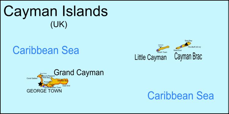
The Cayman Islands are a British dependency and island country. It is a three-island archipelago in the Caribbean Sea, consisting of Grand Cayman, Cayman Brac, and Little Cayman. Georgetown, the capital of the Cayman Islands is 438 km (272 mi) south of Havana, Cuba, and 504 km (313 mi) northwest of Kingston, Jamaica, northeast of Costa Rica, north of Panama and are between Cuba and Central America. Georgetown’s geographic coordinates are 19.300° north, 81.383° west.
Contents
The Cayman Islands have a land area of 264 km2 (102 sq mi) approximately 1.5 times the size of Washington, D.C. and just 3 km2 (1.2 sq mi) larger than Saint Kitts and Nevis. The Cayman Islands have a coastline of 160 km (99 mi). The Cayman Islands make a maritime claim of a 200-nautical-mile (370.4 km; 230.2 mi) exclusive fishing zone and a territorial sea of 12 nautical miles (22.2 km; 13.8 mi).
Geology
The islands are located on the Cayman Rise which forms the northern margin of the Cayman Trough. The trough is the deepest point in the Caribbean Sea and forms part of the tectonic boundary between the North American Plate and the Caribbean Plate. The Cayman Rise extends from southeastern Cuba along the northern margin of the Cayman Trough toward Costa Rica and resulted from Paleocene to Eocene island arc formation with associated volcanism along an extinct subduction zone. The islands are formed of marine limestone and dolostone that was uplifted during the late Miocene epoch. Due to the Islands' location, the Cayman Islands do get Earthquakes.
Climate
The Cayman Islands have a tropical marine climate, with a wet season of warm, rainy summers (May to October) and a dry season during the winter (November to April). Terrain is mostly a low-lying limestone base surrounded by coral reefs.
Beside earthquakes another major natural hazard is the tropical cyclones that form during the Atlantic hurricane season from July to November.
Environmental issues
An important environmental issue is the lack of fresh water resources. Drinking water supplies must be met by rainwater catchment and desalination.
Districts
The territory is subdivided into six districts that are governed by district managers and that have a role as electoral districts and as regional units for statistics. Five of the districts are located on the main island, Grand Cayman. The sixth, Sister Islands, comprises the islands of Little Cayman and Cayman Brac.
The population is concentrated in the three (south-)western districts George Town (capital), West Bay, and Bodden Town. Those have a population density many times higher than all remaining districts.