
Coastline 207 km (128.6 mi) | Area 2,512 km (970 sq mi) Highest elevation 3,069 m (10,069 ft) | |
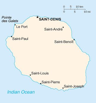 | ||
Réunion is an island in Southern Africa, in the Indian Ocean, east of Madagascar. It is an overseas region of France. The total area of the island is 2,512 km², of which 10 km² is water. The island has a coastline of 207 km. The maritime claims of Réunion include an exclusive economic zone of 200 nautical miles, and a territorial sea of 12 nautical miles (22 km).
Contents
Climate
The climate in Réunion is tropical, but temperature moderates with elevation. The weather is cool and dry from May to November, and hot and rainy from November to April. The terrain is mostly rugged and mountainous, with fertile lowlands along the coast. The lowest point is the Indian Ocean and the highest is Piton des Neiges at 3,069 m.
Natural hazards
Local natural hazards include: periodic, devastating cyclones (December to April), and Piton de la Fournaise (2,631 m) on the southeastern coast is an active volcano.