
 | ||
This is the outline of the geography of the city of Ottawa, the capital of Canada. Ottawa's current borders were formed in 2001, when the former city of Ottawa amalgamated with the ten other municipalities within the former Regional Municipality of Ottawa-Carleton. Ottawa is now a single-tiered Census division, home to 870,250 people.
Contents
- Former townships
- Physical geography
- Rivers and creeks
- Features of the Ottawa River
- Features of the Rideau River
- Lakes
- Other geographical features
- References
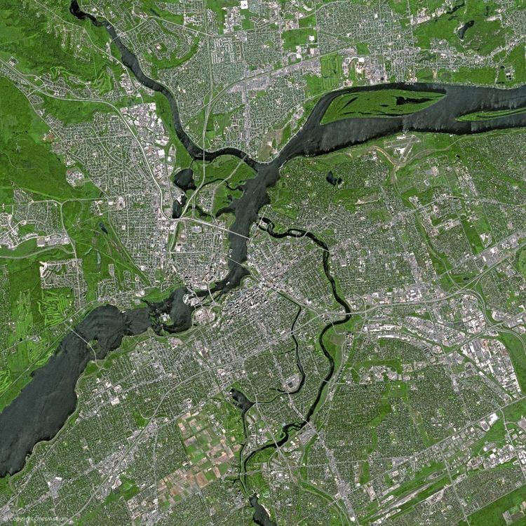
The city centre is located at the confluence of the Ottawa and Rideau Rivers. The Ottawa River forms the entire northern boundary of the city which it shares with the province of Quebec's municipalities of Pontiac and Gatineau. The northern boundary begins in the west at Arnprior and continues east to Rockland. The boundary then turns south in a straight line, separating the former Township of Cumberland (now in Ottawa) and the City of Clarence-Rockland. It then turns west in another straight line separating the former Township of Cumberland with the municipalities of The Nation and Russell. It then turns south separating Russell from the former Township of Osgoode (now in Ottawa). That boundary runs south in a straight line, then turns west separating Osgoode from the municipality of North Dundas. That boundary runs west in a straight line before turning north separating Osgoode from the municipality of North Grenville. This is another straight line, running north until the Rideau River near Kemptville. The boundary follows the River upstream until almost reaching Merrickville. The boundary then runs in a northwest direction in a straight line with a number of jogs. It separates the municipalities of Montague, Beckwith and Mississippi Mills from the former townships of Marlborough, Goulbourn, Huntley and Fitzroy.
Former townships
What is now Ottawa was once divided geographically into 11 townships. Ten of them in the former Carleton and one (Cumberland) in the former Russell County. The ten townships of Carleton were Fitzroy, Gloucester, Goulbourn, Huntley, March, Marlborough, Nepean, North Gower, Osgoode and Torbolton.
Physical geography
The highest point in the city is 166 m (545 ft) above sea level, and is located 2.6 km SSE of Manion Corners (45° 14' 5" N; 76° 3' 3" W). [1] The lowest point in the city is the Ottawa River, at 44m above sea level.
Rivers and creeks
Features of the Ottawa River
(from East to West)
Features of the Rideau River
(from North to South)