
Continent Africa Area Ranked 48th | Coastline 0 km (0 mi) | |
 | ||
Borders Total land borders: 4,374.15 km (2,717.97 mi)Namibia: 1,544 km (959 mi)South Africa: 1,969 km (1,223 mi)Zambia: 0.15 km (0.093 mi)Zimbabwe: 834 km (518 mi) Highest point Tsodilo Hills 1,489 m (4,885 ft) | ||
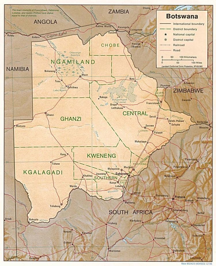
Botswana is a landlocked country located in Southern Africa, north of South Africa. Botswana occupies an area of 581,730 square kilometres (224,610 sq mi), of which 566,730 km2 (218,820 sq mi) are land. Botswana has land boundaries of combined length 4,347.15 kilometres (2,701.19 mi), of which the constituent boundaries are shared with Namibia, for 1,544 km (959 mi); South Africa 1,969 km (1,223 mi); Zimbabwe, 834 km (518 mi) and Zambia, 0.15 km (0.093 mi). Much of the population of Botswana is concentrated in the eastern part of the country.
Contents
Sunshine totals are high all year round although winter is the sunniest period. The whole country is windy and dusty during the dry season.
Climate
Botswana is semi-arid, due to the short rain season. However, the relatively high altitude of the country and its continental situation gives it a subtropical climate. The country is remote from moisture-laden air flows for most of the year. The dry season lasts from April to October in the south and to November in the north where, however, rainfall totals are higher. The south of the country is most exposed to cold winds during the winter period (early May to late August) when average temperatures are around 14 °C (57.2 °F). The whole country has hot summers with average temperatures around 26 °C (78.8 °F). Sunshine totals are high all year round although winter is the sunniest period. The whole country is windy and dusty during the dry season.
Geography
The land is predominantly flat to gently undulating tableland, although there is some hilly country, where mining is carried out. The Kalahari Desert is in the central and the southwest. The Okavango Delta, one of the world's largest inland deltas, is in the northwest and the Makgadikgadi Pans, a large salt pan lies in the north-central area. The Makgadikgadi has been established as an early habitation area for primitive man; This large seasonal wetland is composed of several large component pans, the largest being Nwetwe Pan, Sua Pan and Nxai Pan. Botswana's lowest elevation point is at the junction of the Limpopo and Shashe Rivers, at a height of 513 m (1,683 ft). The highest point is Monalanong Hill, at 1,494 m (4,902 ft). The country is divided into four drainage regions, which are sometimes indistinct due to the arid nature of the climate:
Except for the Chobe, Okavango, Boteti and Limpopo rivers, most of Botswana's rivers cease to flow during the dry and early rainy seasons.
Natural hazards
Botswana is affected by periodic droughts, and seasonal August winds blow from the west, carrying sand and dust, which can obscure visibility.
Environment
Current environmental issues in Botswana are overgrazing, desertification and the existence of only limited fresh water resources.
Research from the University of Botswana has found that the common practice of overstocking cattle to cope with drought losses actually depletes scarce biomass, making ecosystems more vulnerable. The study of the Kgatleng district predicts that by 2050 the cycle of mild drought is likely to become shorter —18 months instead of two years—due to climate change.
International agreements
Botswana is a party to the following international agreements: Biodiversity, Climate Change, Desertification, Endangered Species, Hazardous Wastes, Law of the Sea, Nuclear Test Ban, Ozone Layer Protection and Wetlands.
Extreme points
This is a list of the extreme points of Botswana, the points that are farther north, south, east or west than any other location.