
 | ||
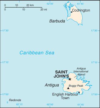
Antigua and Barbuda lie in the eastern arc of the Leeward Islands of the Lesser Antilles, separating the Atlantic Ocean from the Caribbean Sea. Antigua is 650 km southeast of Puerto Rico; Barbuda lies 48 km due north of Antigua, and the uninhabited island of Redonda is 56 km southwest of Antigua.
Contents
- Mountains and Hills
- Oceans and Seas
- The Coast and Beaches
- Wind
- Rainfall and temperature
- Vegetation
- Statistics
- References
The largest island Antigua, is 21 km (about a dozen miles) across and 281 km² (about a hundred square miles) in area. Barbuda covers 161 km² while Redonda encompasses a 2.6 km². The capital of Antigua and Barbuda is St. John's, located at St. John's Harbour on the northwest coast of Antigua. The principal city of Barbuda is Codrington, located on Codrington Lagoon.
Mountains and Hills
Antigua and Barbuda both are generally low-lying islands whose terrain has been influenced more by limestone formations than volcanic activity. The highest point on Antigua is Mount Obama (formerly Boggy Peak), the remnant of a volcanic crater rising 402 metres (1319 ft). This mountain is located amid a bulge of hills of volcanic origin in the southwestern part of the island.
The limestone formations in the northeast are separated from the southwestern volcanic area by a central plain of clay formations. Barbuda's highest elevation is 42 metres (146 ft), part of the highland plateau east of Codrington. The shorelines of both islands are greatly indented with beaches, lagoons, and natural harbours. The islands are rimmed by reefs and shoals. There are few streams as rainfall is slight. Both islands lack adequate amounts of fresh groundwater. Redonda has no significant elevation.
Neither Barbuda nor Redonda have any significant elevations.
Oceans and Seas
Antigua and Barbuda are located in the eastern Caribbean Sea. The open Atlantic Ocean lies to the north and east. There are many coral reefs in the vicinity of Antigua and Barbuda. The island of Guadeloupe lies to the south, on the far side of the Guadeloupe Passage from Antigua.
The Coast and Beaches
Antigua and Barbuda is famous for its beaches, estimated at 365, particularly those on Antigua itself. The most noteworthy feature of Barbuda’s coastline is the natural lagoon on the western side of the island.
Wind
The islands' tropical climate is moderated by fairly constant northeast tradewinds, with velocities ranging between 30 and 48 km/h (19 and 30 mph). There is little precipitation because of the islands' low elevations.
Rainfall and temperature
Rainfall averages 990 mm (39 in) per year, with the amount varying widely from season to season. In general the wettest period is between September and November. The islands generally experience low humidity and recurrent droughts.
Hurricanes strike on an average of once a year. Temperatures average 27 °C (80.6 °F), with a range from 23 °C (73.4 °F) in the winter to 30 °C (86 °F) in the summer and autumn. The coolest period is between December and February. Its low humidity makes it one of the most temperate climates in the world.
Vegetation
The sandy soil on much of the islands has only scrub vegetation. Some parts of Antigua are more fertile–most notably the central plain–due to the volcanic ash in the soil. These areas support some tropical vegetation and agricultural uses. The planting of acacia, mahogany, and red and white cedar on Antigua has led to as much as 11% of the land becoming forested, helping to conserve the soil and water.