 | ||
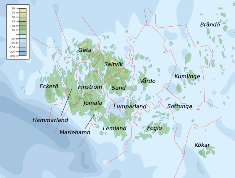
The Åland archipelago consists of nearly three hundred inhabitable islands, of which about sixty are inhabited; the remainder are some 6,400 skerries and desolate rocks. The archipelago is connected to Turku archipelago in the east (Finnish: Turunmaan saaristo, Swedish: Åbolands skärgård) — the archipelago adjacent to the southwest coast of Finland.
Contents
The islands' landmass occupies a total land area of 1,553 square kilometres (600 sq mi), and a total area, including inland water and sea areas, of 13,324 square kilometres (5,144 sq mi). Its highest point is Orrdalsklint in Saltvik at 129.1 m above sea level. Åland has nearly 400 lakes of over 0.25 hectare.
The surface of the islands are generally rocky, with red and pink granite peppered with quartz crystals predominating. The soil is thin, stripped away by retreating glaciers at the end of the most recent ice age. Despite this, the presence of shell beds around the coasts of many of the islands has noticeably increased the fertility of the soil.
The coast of Åland is deeply indented by bays and fjords, which form excellent sheltered harbours for vessels of draught not exceeding 19 ft. The most notable harbour is at Ytternäs. The large islands of Eckerö, Lemland, and Lumparland are separated from Åland and each other by narrow shallow straits. The islands of Fölglö, Vårdö, and the archipelago of Geta are more massive, with steep cliffs and a less indented coastline. Many small lakes exist on the larger islands.
Ninety per cent of the population live on Fasta Åland (the Main Island), also the site of the capital town of Mariehamn. Fasta Åland is the largest island in the archipelago, although its exact size is in some dispute owing to its irregular shape and coastline. Estimates range from 740 square kilometres to 879 square kilometres to over 1,010 square kilometres, depending on what is included or excluded.
Flora and fauna
The mildness of the climate and the richness of the soil tend to the growth of a more luxuriant vegetation than on the mainland of Finland. Pines and firs, birch, aspen, elm, ash, and lime grow, and oaks occur in small woods all over Åland. Traditionally, timber was exported for shipbuilding, and local clay was used in the tile and brickworks on Åland.
Flocks of seabirds live on the rocky islets. Traditionally, migratory birds were hunted by the inhabitants, but the native sea-birds were protected, and their eggs used as food. The islets of Lågskär, Klåfskär and Signilskär were the traditional home to colonies of eider-duck, whose down was collected from the nests after the young had left, for export.
Mapping
A transnational Euroregion encompasses Åland and nearby coastal archipelagoes (skärgårdar). During the Åland crisis, the parties sought support from different maps of the islands. On the Swedish map, the most densely populated main island dominated, and many skerries were left out. On the Finnish map, a lot of smaller islands or skerries were, for technical reasons, given a slightly exaggerated size. The Swedish map made the islands appear to be closer to the mainland of Sweden than to Finland; the Finnish map stressed the continuity of the archipelago between the main island and mainland Finland, while a greater gap appeared between the islands and the archipelago on the Swedish side. Although both Finns and Swedes argued for their respective interpretations, in retrospect it is hard to say that one is more correct than the other. One consequence is the oft-repeated number of "over 6,000" skerries, that was given authority by the outcome of the arbitration.
