
Demonym(s) Gennepenaar, Genneper Postcode 6590–6599 Area 50.4 km² Local time Sunday 1:25 AM | Elevation 13 m (43 ft) Time zone CET (UTC+1) Website www.gennep.nl Area code 0485 | |
 | ||
Weather 7°C, Wind E at 11 km/h, 64% Humidity Points of interest Museum Het Peter, Sint‑Martinustoren, De Crypte | ||
Gennep ( pronunciation ) is a municipality and a city in upper southeastern Netherlands. It lies in the northern part of the province of Limburg. Furthermore, it lies on the right bank of the Meuse river, and south of the forest of the Klever Reichswald. The municipality of Gennep has 17,277 inhabitants (2014).
Contents
Map of Gennep, Netherlands
The Niers river flows into the Meuse in Gennep.
Population centres
Aaldonk, Dam, De Looi, Diekendaal, Gennep, Heijen, Hekkens, Milsbeek, Ottersum, Smele, Ven-Zelderheide, and Zelder.
Dutch topographic map of the municipality of Gennep, June 2015
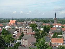
The city of Gennep
Gennep was the title of a comital family, known descendants of which are the famous Saint Norbert of Gennep and William of Gennep, Archbishop-Elector of Cologne.
Gennep probably received city rights in 1371. However, it remains unclear whether these city rights have really been assigned to Gennep, as the supposed documents burned during a fire in the townhall of Gennep at the end of the 16th century. Gennep lies about 18 kilometres (11 miles) southeast of Nijmegen.
In 2001, Gennep had 8306 inhabitants. The built-up area of the town was 2.11 square kilometres (0.81 sq mi), and contained 3124 residences.
Twin towns — Sister cities
Gennep is twinned with: