Samiksha Jaiswal (Editor)

Galguduud

Updated on
Edit
Like
Comment
Share on FacebookTweet on TwitterShare on LinkedInShare on Reddit
Country
  
Time zone
  
EAT (UTC+3)

Capital
  
Dhusamareb

Regional State
  
Area
  
46,126 km²

Galguduud httpsuploadwikimediaorgwikipediacommonsthu

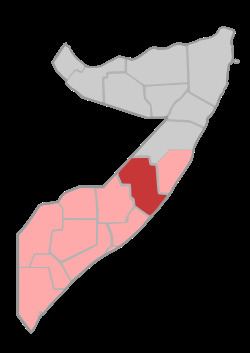
Galguduud (Somali: Galgaduud, Arabic: جلجدود‎‎) is an administrative region (gobol) in central Somalia.

Contents

Map of Galguduud, Somalia

Overview

It is bordered by Ethiopia, the Somalian regions of Mudug, Hiran and Middle Shebelle (Shabeellaha Dhexe), and the Indian Ocean.

Galguduud's capital is Dhusamareb.

Districts

The Galguduud region consists of eight districts:

  • Abudwaq District
  • Adado District
  • Gal,ad Distract
  • Dhusa Mareb District
  • El Buur District
  • El Dher District
  • balanballe Distract
  • Guriel District
  • Major towns

  • Abudwak
  • Adado
  • Balan-Bale
  • Dhusamareb
  • El Buur
  • Galhareeri
  • El Garas
  • Galinsoor
  • Guriel
  • Herale
  • Wahbo
  • Masagaway
  • Baraag sheikh caamir
  • Ceeldhere
  • Bajag
  • Waniinle
  • Cigo
  • Maraysuuley
  • Tixle
  • Tuulo aflax
  • References

    Galguduud Wikipedia


    Similar Topics