
Opening date 1953 Surface area 90.65 km² Impound Gal Oya | Status Operational Construction began 24 August 1949 | |
 | ||
Owner Ministry of Irrigation and Water Resources Management Similar Maskeliya Dam, Bowatenna Dam, Udawalawe Dam, Kukule Ganga Dam, Uthuru Janani Power St | ||
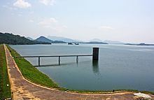
The Gal Oya Dam (also known as Inginiyagala Dam) is an embankment dam in the Uva Province of Sri Lanka. The dam creates one of the largest and most iconic reservoirs in the country, the Gal Oya Reservoir. Water from the reservoir is used primarily for irrigation in the Uva and Eastern provinces, in addition to powering a small hydroelectric power station. Construction of the dam and reservoir began in August 24, 1949 (1949-08-24), completing four years later in 1953 (1953).
Contents
Map of Gal Oya Dam, Sri Lanka
Dam and reservoir
The dam is constructed between two hills at the small town of Inginiyagala, measuring 3,600 ft (1,100 m) and 140 ft (43 m) in length and height respectively, consisting of 2,000,000 cu yd (1,500,000 m3) of soil. The dam, built by Morrison-Knudsen company, creates the Gal Oya Reservoir.
The reservoir, also known as the Inginiyagala Reservoir, and more commonly as the Senanayake Samudraya (after D.S. Senanayake), has a total storage of 770,000 acre·ft (950,000,000 m3) and a surface area of 35 sq mi (91 km2).
Power station
In addition to downstream irrigation, water from the reservoir is used to power the Inginiyagala Power Station, a hydroelectric power station located immediately downstream of the dam. The power station consists of four units of (2.475MWx2 & 3.15MWx2)11.25 MW, commissioned in 1952 unit 1,2 & 1962 unit 3,4.