
 | ||
Augmentation of a global navigation satellite system (GNSS) is a method of improving the navigation system's attributes, such as accuracy, reliability, and availability, through the integration of external information into the calculation process. There are many such systems in place and they are generally named or described based on how the GNSS sensor receives the external information. Some systems transmit additional information about sources of error (such as clock drift, ephemeris, or ionospheric delay), others provide direct measurements of how much the signal was off in the past, while a third group provide additional vehicle information to be integrated in the calculation process.
Contents
Satellite-based augmentation system
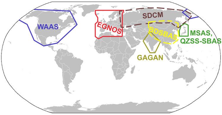
A satellite-based augmentation system (SBAS) is a system that supports wide-area or regional augmentation through the use of additional satellite-broadcast messages. Such systems are commonly composed of multiple ground stations, located at accurately-surveyed points. The ground stations take measurements of one or more of the GNSS satellites, the satellite signals, or other environmental factors which may impact the signal received by the users. Using these measurements, information messages are created and sent to one or more satellites for broadcast to the end users. SBAS is sometimes synonymous with WADGPS, wide-area DGPS.
Implementations
For details on how various SBAS are implemented, please see the following articles:
Ground-based augmentation system
Each of the terms ground-based augmentation system (GBAS) and ground-based regional augmentation system (GRAS) describe a system that supports augmentation through the use of terrestrial radio messages. As with the satellite based augmentation systems detailed above, ground based augmentation systems are commonly composed of one or more accurately surveyed ground stations, which take measurements concerning the GNSS, and one or more radio transmitters, which transmit the information directly to the end user from the ground up thus avoiding the constraints associated with GEO Satellites at high latitudes.
Generally, GBAS is localized, supporting receivers within 23 nautical miles, and transmitting in the very high frequency (VHF) band.
The shorter the distance between the ground station that calculates the differential corrections to the inbound plane, the higher the accuracy is likely to be. There are stricter Safety requirements on GBAS systems relative to SBAS systems since GBAS is intended mainly for the landing phase where real-time accuracy and signal integrity control is critical, especially when weather deteriorates to the extent that there is no visibility (CAT-I/II/III conditions) for which SBAS is not intended or suitable.
Various ground-based augmentation systems
Additional navigation sensors
The augmentation may also take the form of additional information being blended into the position calculation. Many times the additional avionics operate via separate principles than the GNSS and are not necessarily subject to the same sources of error or interference. A system such as this is referred to as an aircraft-based augmentation system (ABAS) by the ICAO.
The additional sensors may include: