
Operator(s) GSA, ESA Status Operational | Type Augmentation | |
 | ||
The European Geostationary Navigation Overlay Service (EGNOS) is a satellite based augmentation system (SBAS) developed by the European Space Agency, the European Commission and EUROCONTROL. It supplements the GPS, GLONASS and Galileo satellite navigation systems by reporting on the reliability and accuracy of their positioning data and sending out corrections.
Contents
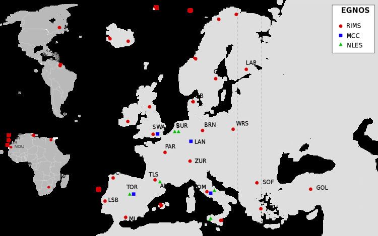
EGNOS consists of a network of about 40 ground stations and 3 geostationary satellites. Ground stations determine accuracy data of the satellite navigation systems and transfer it to the geostationary satellites; users may freely obtain this data from those satellites using an EGNOS-enabled receiver, or over the internet. One main use of the system is in aviation.
According to specifications, horizontal position accuracy when using EGNOS-provided corrections should be better than seven metres. In practice, the horizontal position accuracy is at the metre level.
Similar service is provided in North America by the Wide Area Augmentation System (WAAS), and in Asia, by Japan's Multi-functional Satellite Augmentation System (MSAS) and India's GPS Aided GEO Augmented Navigation (GAGAN).
History and roadmap
The system started its initial operations in July 2005, with accuracy better than two metres and availability above 99%. As of July 2005, EGNOS has been broadcasting a continuous signal, and at the end of July 2005 the system was again used to track cyclists in the Tour de France road race.
In 2009, the European Commission announced it had signed a contract with the company European Satellite Services Provider to run EGNOS. The official start of operations was announced by the European Commission on 1 October 2009. The system was certified for use in safety of life applications in March 2011. An EGNOS Data Access Service became available in July 2012.
Initial work to extend EGNOS coverage to the Southern Africa region is being done under a project called ESESA - EGNOS Service Extension to South Africa.
The European Commission is defining the roadmap for the evolution of the EGNOS mission. This roadmap should cope with legacy and new missions:
Satellites and SISNeT
Similar to WAAS, EGNOS is mostly designed for aviation users who enjoy unperturbed reception of direct signals from geostationary satellites up to very high latitudes. The use of EGNOS on the ground, especially in urban areas, is limited due to relatively low elevation of geostationary satellites: about 30° above horizon in central Europe and much less in the North of Europe. To address this problem, ESA released in 2002 SISNeT, an Internet service designed for continuous delivery of EGNOS signals to ground users. The first experimental SISNeT receiver was created by the Finnish Geodetic Institute. The commercial SISNeT receivers have been developed by Septentrio.
Ground stations
More than 40 ground stations are linked together to create EGNOS network which consists:
Aviation
In March 2011, the EGNOS Safety of Live Service was deemed acceptable for use in aviation. This allows pilots throughout Europe to use the EGNOS system as a form of positioning during an approach, and allows pilots to land the aircraft in IMC using a GPS approach.
As of September 2014 LPV (Localizer performance with vertical guidance) landing procedures, which are EGNOS-enabled, were available at more than 114 airports across Europe.