
Time zone EET (UTC+2) Licence plate 68 Elevation 1,485 m Local time Monday 4:06 AM | Region Central Anatolia Postal code 68xxx Website www.guzelyurt.gov.tr Area 322 km² Area code 0382 | |
 | ||
Weather 2°C, Wind SW at 5 km/h, 94% Humidity | ||
Güzelyurt, formerly Gelveri, is a town and district of Aksaray Province in the Central Anatolia region of Turkey, at a distance of 45 km (28 mi) from the city of Aksaray. According to 2000 census, population of the district is 16,836 of which 3,775 live in the town of Güzelyurt. The district covers an area of 322 km2 (124 sq mi), and the average elevation is 1,485 m (4,872 ft).
Contents
Map of G%C3%BCzelyurt, 68500 G%C3%BCzelyurt%2FAksaray, Turkey
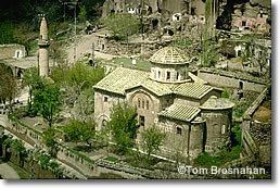
This is an area of great natural beauty and historical importance, part of the ancient region of Cappadocia, near the much-visited Ihlara Valley.
History
Cappadocia has an important place in the history of Christianity and Gregory of Nazianzus lived in the area. A historically large Greek population existed in the area until the 1924 population exchange (see Cappadocian Greeks), when they were replaced with the Turks from Thessaloniki and Kavala.
Places of interest
Güzelyurt is known for having three underground cities and over 50 churches carved into the rocky volcanic landscape including:
Other places of interest include...