
Elevation 885 m (2,904 ft) Postal code 50xxx Area 956 km² Local time Monday 2:25 AM | Region Central Anatolia Time zone EET (UTC+2) Licence plate 50 Area code 0384 | |
 | ||
Weather 6°C, Wind SE at 0 km/h, 82% Humidity | ||
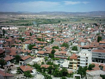
Gülşehir, formerly Arapsun, ancient Zoropassos (Ancient Greek: Ζωρόπασος), is a town and district of Nevşehir Province in the Central Anatolia region of Turkey, in the vicinity of the Fairy Chimney valley of Göreme. According to 2010 census, population of the district is 24,503 of which 8,866 live in the town of Gülşehir, and the remainder in surrounding villages. The district covers an area of 956 km2 (369 sq mi), and the average elevation is 885 m (2,904 ft).
Contents
Map of G%C3%BCl%C5%9Fehir, 50900 G%C3%BCl%C5%9Fehir%2FNev%C5%9Fehir, Turkey
History
The old name of Gülşehir, situated on the southern bank of the Kızıl River, 20 km from Nevşehir, is Arapsun and in ancient times it was called “Zoropassos” by the Hittites. In the vicinity of Gülşehir there are still rocks and steles with inscriptions from the Hittites.
The Ottoman Grand Vizier Karavezir Mehmet Seyyid Pasha did the same thing in Gülşehir as Damat İbrahim Pasha did in the nearby Nevşehir and a külliye was built in the town which had only 30 houses. The complex consisted of a mosque, a madrasah and a fountain.
The pottery, located completely inside an artificial cave deep in the rock, is a local tourist attraction.