
Time zone EET (UTC+2) Licence plate 52 Elevation 321 m Local time Monday 12:35 AM | Region Black Sea Postal code 52600 Climate Csb Area 341 km² Area code 0452 | |
 | ||
Weather 6°C, Wind SE at 16 km/h, 77% Humidity | ||
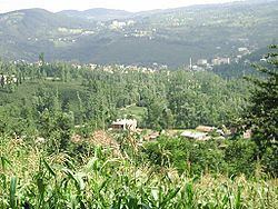
Gölköy is a town and district of Ordu Province in the Black Sea region of Turkey. The town is located 60 km (37 mi) inland from the city of Ordu on the road to Sivas. According to the 2000 census, population of the district is 66,491 of which 24,162 live in the town of Gölköy. The district covers an area of 415 km2 (160 sq mi), and the town lies at an elevation of 1,054 m (3,458 ft).
Map of G%C3%B6lk%C3%B6y, 52600 G%C3%B6lk%C3%B6y%2FOrdu, Turkey
Places of interest include the Byzantine castle of Habsamana, and a number of places of natural beauty for walking and climbing including the village of Cihadiye and the lake of Ulugöl.
The villages of Gölköy district include Ahmetli, Akçalı, Bayıralan, Bulut, Cihadiye, Çatak, Çetilli, Emirler, Güzelyayla, Haruniye, Hürriyet, İçyaka, Kaleköy, Konak, Kozören, Özlü, Süleymaniye, and Yuvapınar.