
Mountain range Alps | Elevation 2,360 m Parent range Tennen Mountains | |
 | ||
Mountain type Ramsau dolomite, Dachstein limestone Similar Bleikogel, Tauernkogel, Eiskogel, Raucheck, Wieselstein | ||
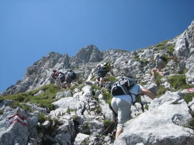
The Fritzerkogel is a mountain in the Tennengebirge (Tennen Mountain Range) in the northern Limestone Alps, Austria. With its elevation of 2,360 metres (7,740 ft), is one of the higher peaks in the mountain range. Seen from the north it stands out as a relatively isolated, broad summit block, whose mighty rock faces and steep, rugged, rocky flanks (Schrofen) fall away on all sides. Its 1,200-metre-high (3,900 ft) south cliff face is impressive and makes it a striking two-thousander.
Contents
Map of Fritzerkogel, 5523, Austria
GeneralEdit
The Fritzerkogel rises in the eastern part of the Tennen mountains high above the valley of the Lammer between Abtenau and Anne-Lungötz, directly opposite the Gosau ridge, the Bischofsmütze and the Dachstein mountains. Further to the west is the actual karst plateau of the Tennen mountains, behind the Bleikogel mountain. As a solitary peak, the Fritzerkogel offers a good view in all directions. It is therefore climbed frequently. Tours to the summit depart from the Laufen Hut of the German Alpine Club.
The peak Kleiner Fritzerkogel ("Little Fritzerkogel") lies slightly west of the Fritzerkogel, elevation (2,207 metres (7,241 ft)), 47°30′37″N 13°18′56″E, which is why Fritzerkogel is sometimes called Großer Fritzerkogel ("Great Fritzerkogel").
RoutesEdit
The Fritzerkogel is one of the most popular mountains in the Tennengebirge, however climbing it is not straightforward. Prerequisites are sure-footedness, a head for heights, good physical fitness, and alpine experience. Unexpected hazards such as fog, leading to disorientation, and sudden storms have given the region a feared reputation amongst climbers.
The typical ascent to the Laufen Hut begins in Abtenau. From the hut, there are two routes: