
OS grid reference TF737346 Sovereign state United Kingdom Area 6.93 km² | Civil parish Fring Post town KING'S LYNN | |
 | ||
District | ||
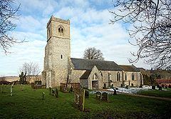
Fring is a civil parish in the English county of Norfolk. It covers an area of 6.93 km2 (2.68 sq mi) and had a population of 94 in 41 households at the 2001 census. The population remained less than 100 at the 2011 Census and qwas included in the civil parish of Sedgeford. For the purposes of local government, it falls within the district of King's Lynn and West Norfolk. There is a small cluster of buildings located along Fring road consisting of Fring All Saints.
Map of Fring, UK
In 1870-72 Fring was described as:
"a parish in Docking district, Norfolk; 2¾ miles SW of Docking, and 2 ESE of Sedgeford r. station. Post town, Docking, under Lynn. Acres, 1, 710. Real property, £2, 065. Pop., 173. Houses, 37."
References
Fring, Norfolk Wikipedia(Text) CC BY-SA