
Airport type Public 12/30 3,627 Code FCH Phone +1 559-621-4500 | Owner City of Fresno Elevation AMSL 279 ft / 85 m 3,627 1,106 Elevation 85 m | |
 | ||
Address 510 W Kearney Blvd, Fresno, CA 93706, USA Similar Fresno Yosemite Internatio, Sierra Sky Park, Mazzei Flying Service, American Helicopters, Memley Aviation | ||
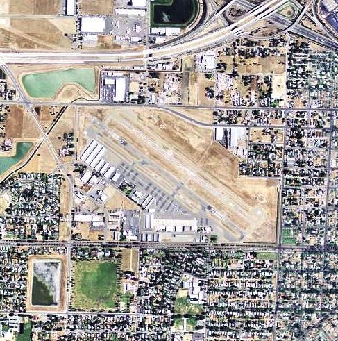
Landing pattern at kfch fresno chandler executive airport
Fresno Chandler Executive Airport (IATA: FCH, ICAO: KFCH, FAA LID: FCH) is a public use airport two miles (3 km) west of the central business district of Fresno, in Fresno County, California, United States. It is owned by the City of Fresno and the designated airport manager is Rick Duncan.
Contents
- Landing pattern at kfch fresno chandler executive airport
- Night landing at the fresno chandler executive airport bright runway lights
- Facilities and aircraft
- World War II
- References
Chandler is a regional reliever airport; since 1947 scheduled airlines have used Fresno Yosemite International Airport 6 miles (9.7 km) northeast. Sierra Sky Park Airport, a privately owned airport open to the public, is 22 kilometres (14 mi) north.
Night landing at the fresno chandler executive airport bright runway lights
Facilities and aircraft
Fresno Chandler Executive Airport covers 200 acres (81 ha) at an elevation of 279 feet (85 m) above mean sea level. It has one asphalt paved runway designated 12/30 that is 3,630 by 75 feet (1,106 by 23 m).
For the 12-month period ending March 2, 2007 the airport had 25,000 general aviation aircraft operations, an average of 68 per day. At that time there were 126 aircraft based at this airport: 83% single-engine, 6% multi-engine, 1% jet, 4% helicopter, 6% ultralight.
World War II
The United States Army Air Corps Southwest Air District took over the airport in early 1941 while nearby Hammer Army Airfield was being built. In June 1942 Hammer AAF opened and all military activity moved there.