
Name Franz Schrader | Role Mountaineer | |
 | ||
Died October 18, 1924, Paris, France | ||
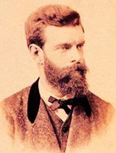
Jean Daniel François Schrader, better known as Franz Schrader, was a French mountaineer, geographer, cartographer and landscape painter, born January 11, 1844 in Bordeaux, died October 18, 1924 in Paris. He made an important contribution to the mapping of the Pyrenees and was highly considered among the pyreneists.
Contents
Biography
He is the son of Prussian Ferdinand Schrader from Magdeburg, who emigrated to Bordeaux, and of Marie-Louise Ducos, from a family of Nérac, and cousin of geographers Élisée and Onésime Reclus. He shows a talent for drawing from an early age. But his strict father, denying him the opportunity of higher education, places him as a pen pusher at a tax gatherer. Franz then finds another job in a trading house run by one of his father's friends, a situation where he can devote more time to broadening his literary and scientific knowledge.
In 1866, while staying with his friend Léonce Lourde-Rocheblave in Pau, he has a sort of revelation at the spectacle grandiose de la barrière montagneuse of the Pyrenees. His vocation strengthens when reading stories by Ramond de Carbonnières (1755-1827) (Les Voyages au Mont-Perdu - Travels to Monte Perdido) and by Henry Russell (1834-1909) (Les Grandes Ascensions des Pyrénées, guide d'une mer à l'autre - Great ascents of the Pyrenees, a guide from one sea to the other). While devoting the main part of his leisure to long hikes in the mountains, during which he gathers thousands of observations for his topographical records, he still finds time to paint numerous panoramas of the Pyrenees as well as the Alps which he also studies, and to acquire a solid formation in topography.
While Schrader scours the Pyrenees with his friend Lourde-Rocheblave, he also acquires a strong background in cartography with the aim of applying it to a large scale map of the nearby Pyrenees. To facilitate topographical work in rugged terrain, he develops the orograph in 1873. His first great cartographic work, in 1874, is the map of the massif of Gavarnie-Mont-Perdu at a scale of 1:40 000, for which he collects the measurements with the participation of Lourde-Rocheblave from nearby Pau. That map triggers such a sensation that it is included in the annual Mémoires of the Société des Sciences Physiques et Naturelles of Bordeaux with an explanatory text the following year. The Club alpin français directory follows with the publication of an enthusiastic review, describing Schrader as qualified for "first rank topographer in a glorious master stroke". In 1876 he takes part in the creation of the Bordeaux section of the Club Alpin Français, becoming its first president.
In 1877 he travels to Paris with a recommendation from his cousins Élisée and Onésime Reclus. There, having met Émile Templier, nephew and collaborator of Louis Hachette, and Adolphe Joanne, president of the Parisian section of the Club Alpin Français, he is employed as a geographer by Librairie Hachette and is now able to practice his passion in the scope of his profession. He also gives geography lessons at the School of Anthropology and also becomes editor of the French Alpine Club directory.
On August 11, 1878, accompanied by high-mountain guide Henri Passet, he carries out the first known ascension of the Grand Batchimale (3,176 m), consequently renamed pic Schrader.
In 1880, he is promoted director of cartography for Hachette and aims at surpassing in quality the Stieler Atlas, by German Adolf Stieler. On November 25, 1897, as vice-president of the C.A.F. he holds a conference at the Club Alpin which constitutes his true esthetic credo of the mountain and in which he announces the imminent foundation of a French school of mountain painting. The conference text title is : À quoi tient la beauté des montagnes (What makes the beauty of mountains); this speech is considered as the birth bulletin of la Société des peintres de montagne (Paris) and its text is reproduced in 1898 in the Club Alpin Français directory.
From 1901 to 1904, he presides le Club Alpin Français. He also actively contributes to the Guides Joanne of the Librairie Hachette, which in 1919 became the Guides bleus.
The scientific commission created by Franz Schrader in the Club Alpin Français still exists today, as well as the Société des Peintres de Montagne.
In 1927, three years after his death, his remains are transferred to a tomb on a slope of the cirque de Gavarnie.
The orograph
Named from ancient Greek word for "mountain", and -graph, the orograph is developed at the turn of the 1870s. It is designed to take precise measurements of mountains. One of its characteristics is its ease of transport: it is small enough to be carried while scrambling in the mountain.
It is equipped with a sort of telescope that the operator moves along the relief, linked to a rule carrying a pen. The pen draws onto a paper disk that registers the lines on which the telescope is aimed. It thus creates an instant graph of said relief.
Atlas
Topography
Paintings
Non-comprehensive list (several hundreds of landscape paintings)
Geography lessons
In collaboration with Henri Lemonnier :
In collaboration with Louis Gallouédec :