
Peak Dürrenberg Area 7,054 km² | Elevation 656.4 m (2,154 ft) | |
 | ||
Similar Franconian Forest, Fichtel Mountains, Franconia, Staffelberg, Hesselberg | ||
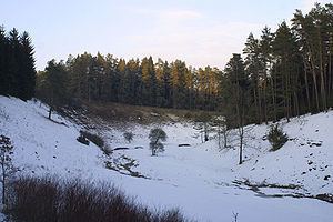
The Franconian Jura (German: Fränkische Alb, Fränkischer Jura, Frankenalb) is an upland in Bavaria, Germany. Located between two rivers, the Danube in the south and the Main in the north, its peaks reach elevations of up to 600 metres (2,000 ft) and it has an area of some 7053.8 km2.
Map of Franconian Jura, 91719 Heidenheim, Germany
Large portions of the Franconian Jura are part of the Altmühl Valley Nature Park. The scenic meanders and gorges formed by the Altmühl River draw tourists to visit the region.
Geologically, the Franconian Jura is the eastern continuation of the Swabian Jura. Both are part of the Jura Mountains. The mountain chains are separated from each other by the impact crater of the Nördlinger Ries.
The northern part of the Franconian Jura is known as Little Switzerland (German: Fränkische Schweiz).