
Gaelic name Fughlaigh OS grid reference HT960392 Highest elevation 418 m | Norse name Fuglaey Area rank 43 Area 12.65 km² Council area Shetland Year first constructed 1986 | |
 | ||
Meaning of name Old Norse for 'bird island' | ||
Plane takes off from island of foula for tingwall shetland scotland uk
Foula (Old Norse Fuglaey, "bird island", compare Norwegian Fugløy, "bird island", Scottish Gaelic Fughlaigh) in the Shetland Islands of Scotland, is one of Great Britain’s most remote permanently inhabited islands. Owned since the turn of the 20th century by the Holbourn family, the island was the location for the film The Edge of the World. RMS Oceanic was wrecked on the nearby Shaalds of Foula.
Contents
- Plane takes off from island of foula for tingwall shetland scotland uk
- Map of Foula Shetland UK
- Foula shetland
- Geography
- Transport
- Wildlife
- Prehistory
- 15th to 19th centuries
- 20th century
- Religion
- Film
- Folklore festivities and traditions
- Poetry
- Geodesy
- References
Map of Foula, Shetland, UK
Foula shetland
Geography
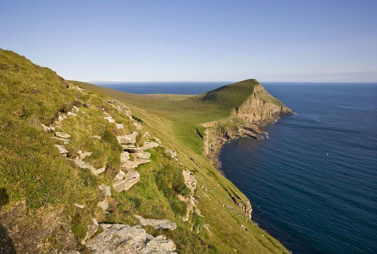
Foula is a bleak yet spectacular island in the Atlantic Ocean, 20 miles west of Walls in Shetland. The island is about 2.5 miles (4.0 km) by 3.5 miles (5.6 km), with a low-lying coastal strip along the east side. With an area of 4.9 square miles (12.7 km2), it is the seventh largest and most westerly of the Shetland Islands. It rises from low broken cliffs in the east to precipitous 150 to 365m cliffs on the west. The island has five peaks, rising to 418m (1371 feet) at the Sneug and 376m (1220 feet) at the Kame. At the north end is Gaada Stack, a natural arch. Foula lies on the same latitude as Saint Petersburg.
Foula has a population of 38 people, living in Hametown and Ham. Islanders previously made a living from fishing – first for whitefish, then lobster. Today, most islanders are crofters with income from sheep farming and ornithological tourism.
A hidden reef, the 'Hoevdi Grund' or the Shaalds o' Foula, lies just over 3 kilometres (1.9 mi) east of Foula between the island and the Shetland mainland. Tides here can reach 12 knots (22 km/h) and as the reef comes to within a few feet of the surface, it poses a significant threat to shipping.
Transport
BK Marine Limited operates the ferry service from Ham to Walls and Scalloway on the Shetland Mainland. The New Advance carries up to 12 passengers and completes the voyage in approximately two hours. Flights take off from Foula's airstrip to Tingwall Airport.
There is little shelter for boats on the island. The only beach is at the head of Ham Voe on the east coast. Local boats, including the mail boat, are hauled out of the water.
Wildlife
The island's 370-metre (1,210 ft) cliffs are home to numerous birds, including Arctic terns, red-throated divers and great skuas.
Prehistory
Foula was first inhabited as far back as 5000 years ago. Between 2006 and 2008, the Bath & Camerton Archeological Society took several trips to Foula to study prehistoric standing stones. A particular sub-circular stone circle of interest was discovered in 2006 at Da Heights on the north of Foula. A further investigation launched in 2007 revealed that the sub-circular stone construction was man-made, elliptical in shape with the axis pointing towards the mid-winter solstice, built before 1000 BCE.
15th to 19th centuries
In 1490, the Ciske family's estates were divided and Vaila and Foula became the property of Alv Knutsson. However, the Ciskes were Norwegian, and as Scotland had annexed Shetland a few decades before, there were confusing and conflicting claims of ownership.
Foula remained on the Julian calendar when the rest of the Kingdom of Great Britain adopted the Gregorian calendar in 1752. Foula adhered to the Julian calendar by keeping 1800 as a leap year, but it did not observe a leap year in 1900. As a result, Foula is now one day ahead of the Julian calendar and 12 days behind the Gregorian, observing Christmas Day on 6 January Gregorian and New Year on 13 January Gregorian.
In 1720, a smallpox epidemic struck the two hundred people living on Foula. Because the islanders were so isolated from the rest of the world, they had no immunity to smallpox, unlike most North European peoples at that time, and nine out of ten of the island's population died in the epidemic.
The writer and journalist John Sands lived on Foula and Papa Stour for a while during the late 19th century. He fought hard against the prevailing truck system and drew political cartoons lampooning its deficiencies. In one, he drew Foula as a beautiful young woman being strangled by a boa-constrictor labelled 'landlordism' watched by other reptiles called 'missionary', 'laird' and 'truck'.
The island was one of the last places where the Norn language was spoken (although it is claimed that Walter Sutherland of Skaw on Unst was the last speaker), and the local dialect is strongly influenced by Old Norse.
20th century
Professor Ian S. Holbourn, the last Laird of Foula, describes the disaster of 8 September 1914, when the White Star Line RMS Oceanic hit the Shaalds o' Foula, becoming a wreck within two weeks. Holbourn's remarkable luck with steamship travel held through the following May, when he embarked upon the RMS Lusitania.
The professor's grandson, Robert Holbourn, a Naval architect, acted as the island's "Peet Marshal" for many years. Peat is valuable and scarce resource for heat and fuel in Shetland. Its cutting requires skill, taking several years to master. The most able islanders become known as the 'Cutters' and, in the spirit of a long-standing Foula tradition, all able-bodied men are now and then 'bid to the banks' of women who 'didn't have a cutter in the house.'
Simon Martin, who stayed on the Isle of Foula for five years during his prolonged claim upon the wrecked Oceanic, describes the island as follows:
"Foula, or Ultima Thule, as it was known as far back as the Roman times, rises impurely out of the water, and from the Shetland Isles mainland its five peaks, the Noup, Hamnafield, the Sneug, Kame and Soberlie stand out starkly and characteristically. The cliffs on the west side vie with those of St Kilda as the highest sheer cliffs in Britain, 1,200-foot (370 m) of solid rock towering from the sea."Foula, or Fughley as it was once also known, means literally 'Bird Island', with an estimated half million birds of various breeds sharing the rock with the inhabitants. The island’s surface largely consisting of a peat bog on rock."A lighthouse at the southern tip of the island was built in 1986. Originally powered by acetylene gas, it has been converted to solar and wind power.
Religion
Many inhabitants of Foula attend a Presbyterian parish known as Foula Kirk or Baxter Chapel that is part of the Church of Scotland. It is made of grey-coloured stone and is situated "on the tail of 7 Hamnafield".
Film
Folklore, festivities, and traditions
Foula's inhabitants preserve many Norse traditions of folklore and festivities. They still follow the Julian calendar for Christmas celebrations, with all the islanders gathering in one house on 6 January. New Year's Day falls on 13 January.
Poetry
Vagaland's poem Da Sang o da Papa men about the fishermen of Papa Stour includes an insistent chorus chant, "Rowin Foula Doon". This refers to the fishermen's practice of rowing their open fishing boat out to sea until the high cliffs of Foula were no longer visible. This entailed the boat's being some 96 kilometres (60 mi) west of Papa Stour. The traditional ballad "Hildina", collected on Foula in 1774, is the only extant poem in the Norn language.
Geodesy
The Sneug on Foula was the origin (meridian) of the 6 inch and 1:2500 Ordnance Survey maps of Orkney and Shetland.