
Year first lit 1897 Foundation Limestone Tower shape Square Range 29,632 m Material Brick Year first constructed 1896 | Automated 1969 Construction Brick Opened 1896 Focal height 20 m Added to NRHP 19 July 1984 | |
 | ||
Location Rogers Township, Michigan Similar Old Presque Isle Light, New Presque Isle Light, Sturgeon Point Light, Cheboygan Crib Light, Pointe aux Barques Light | ||
Forty mile point lighthouse
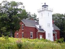
Forty Mile Point Light is a lighthouse in Northern Michigan, in Presque Isle County on Hammond Bay on the western shore of Lake Huron in Rogers Township, Michigan USA. Unlike many Great Lakes lighthouses, Forty Mile Point Light does not mark a significant harbor or river mouth. Rather, it was constructed with the intent that as one sailed from Mackinaw Point to the Saint Clair River, one would never be out of viewing range of a lighthouse. With no river or harbor to use for a name, the light is named on the basis that it is 40 miles (64 km) sailing distance from Mackinaw Point.
Contents
- Forty mile point lighthouse
- Map of 40 Mile Point Lighthouse County Park Rd Rogers City MI 49779 USA
- History
- Current operations maintenance viewing and events
- References
Map of 40 Mile Point Lighthouse, County Park Rd, Rogers City, MI 49779, USA
It is part of U.S. Coast Guard District No. 9.
History
While the Presque Isle Peninsula had been lighted since 1840, and the entrance to the Cheboygan River fifty miles to the north had been lighted since 1851, the New Presque Isle Light's range of visibility of 17 nautical miles; 31 kilometres (19 mi) and the Cheboygan Crib Light's visible range of 11 nautical miles; 21 kilometres (13 mi) left an unlighted 16-nautical-mile; 29-kilometre (18 mi) intervening stretch of coastline along which mariners had to navigate blind. In its annual report for fiscal 1890, the Board recommended that $25,000 be appropriated for the construction of a new light and fog signal at Forty Mile Point near Hammond's Bay, at the approximate midpoint between the two lights.
Congress apparently was unimpressed with the request and it was five years before it was approved and funded. The plan for this light is nearly identical to the one for the Big Bay Point Lighthouse on Lake Superior that was constructed at the same time. The penury of Congress concerning light stations on the Great Lakes was not limited to Forty Mile Point. See, e.g., Port Sanilac lighthouse.
The footings are 20 inches (510 mm) limestone and the structure is 35 by 57 feet (11 m × 17 m). The integrated tower is 12 feet (3.7 m) square and 52 feet (16 m) high. The house contains two identical apartments (presumably for the keeper and the assistant keeper, but ordinarily the assistant got a smaller, not identical apartment). A unique feature is a skylight in the stairs so the keeper or his assistant could observe the light working without going outside or climbing the tower.
The light was completed in November 1896, but traffic on the Great Lakes is not a year round event, so it wasn't until the spring of 1897 that it was first lit. The station was automated in 1969 and is still operational. Foundation materials are wood pilings, and it is constructed of brick in a square shape. Markings are white with a black lantern. Another structure is attached to the tower. The original lens was a fourth order Fresnel lens /freɪˈnɛl/ designed and manufactured by Henry-Lepaute in Paris. It had six bulls-eye flash panels, and the clockwork would rotate it so that it would emit a white flash every ten seconds. The lens now in place is the third or fourth such lens to occupy that position.
Current operations, maintenance, viewing and events
During the Big Blow of 1905, twenty-seven wooden vessels were lost. The steamer Joseph S. Fay ran aground, and a part of its hull rests on the beach approximately 200 feet (61 m) north of the lighthouse. there is a Michigan historical marker honoring Forty Mile Light, there is a marker concerning the "Graveyard of Ships." The marker states:
Indeed, skeletons of ships are only a short distance from the light station. It is listed in the National Register of Historic Places. National Register Reference #84001830 Name of Listing: FORTY MILE POINT LIGHT STATION (U.S. COAST GUARD/GREAT LAKES TR).
The site is now a county park (well-marked) 6 miles (9.7 km) north of Rogers City on US 23, a/k/a the Sunrise Side Coastal Highway. A map with the lights in the area is available at lighthousesRus. The park is accessible from the highway—do not turn on to 40 Mile Point road.
The lighthouse anchors one end of a 7-mile (11 km)bike path that is near and sometimes in the right of way along US 23, and runs by Hoeft State Park and to Rogers City. The bike trail was completed in late May, 2009.
The lighthhouse is owned by Presque County and operated by the 40 Mile Point Lighthouse Society. The park grounds are open to the public year round from 8.00 AM to sundown. The lighthouse is open for tours from the Friday before Memorial Day through the end of the Great Lakes Lighthouse Festival in mid October. Tour hours are Tuesday to Sunday 10:00 a.m. to 4:00 p.m. More information may be obtained from the Rogers City Chamber of Commerce at (800) 622-4148.
Importantly, the many structures that were part of the installation remain: lighthouse; Lighthouse keeper quarters; bunkhouse (newly renovated in 2006-2007), foghorn signal building (the diaphone has been removed), oil house, and brick outhouse. The surrounding park also houses the wheelhouse of the first Calcite freighter.
The fourth order Fresnel lens is in place and in use, and access to the tower provides a view of it and the Lakeshore. The Fresnel lens is still operative, being one of only 70 such lenses that remain operational in the United States, sixteen of which are use on the Great Lakes of which eight are in Michigan.
There are many recurrent events at the lighthouse. A calendar is available.
Half of the lighthouse is now a museum, the other half is caretaker's quarters.
Membership in the 40-Mile Point Lighthouse Society is $20.00 per year, and the Society may be reached at: 40 Mile Point Lighthouse Society, PO Box 205, Rogers City, MI 49779.