
Length 11 km | ||
 | ||
Main source Mullett Lake594 ft (181 m) River mouth Lake Huron at Cheboygan581 ft (177 m) Similar Lake Huron, Cheboygan Crib Light, Poe Reef Light, Aloha State Park, Fourteen Foot Shoal Light | ||
The Cheboygan River is a short but significant river in the Lake Huron drainage basin of the U.S. state of Michigan.
Contents
Map of Cheboygan River, Michigan, USA
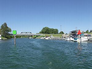
Seven miles (11.3 km) in length, the Cheboygan River flows from the north end of Mullett Lake at 45°34′37″N 84°29′16″W to the Straits of Mackinac at 45°39′22″N 84°27′55″W. The river forms the boundary between Benton Township and Inverness Township before flowing into the city of Cheboygan. The largest tributary is the Black River. The Cheboygan River is entirely contained within Michigan's Cheboygan County, and the county seat of Cheboygan is located at the river's mouth. The river forms the port of Cheboygan and serves as a dock for the ferry boat to Bois Blanc Island and the Coast Guard cutter Mackinaw.
Cheboygan was founded as a lumbering town to cut timbers harvested from the Cheboygan River's drainage and floated down to mills (now mostly vanished) at the mouth of the river. Today, one of the biggest industries of the town and river of Cheboygan is pleasure boating up and down the river. The river is a key artery of the Inland Waterway, a pleasure-boat necklace of waterways in the northern section of Michigan's Lower Peninsula.
The river is the namesake for the city and county.
Description
The Cheboygan River descends 13 feet (4.0 m) in its 6-mile (9.7 km) length, from 594 feet (181 m) above sea level, the level of Mullett Lake, to Lake Huron at 581 feet (177 m) above sea level. The river and other sections of the Inland Waterway are made accessible by locks maintained by the United States Army Corps of Engineers.
The mouth of the Black River, 3.5 miles (5.6 km) south of Cheboygan, is a noted spot to look for bald eagles and other fish-eating raptors.
In Cheboygan itself, U.S. Highway 23 is carried across the Cheboygan River by the Cheboygan Bascule Bridge, a Scherzer rolling lift bridge built in 1940 and added to the National Register of Historic Places in December 1999. In 2009, Cheboygan city authorities built an elevated pedestrian bridge across the Cheboygan near its mouth.
The mouth of the Cheboygan River into Lake Huron is marked by the Cheboygan Crib Light.