
Prominence 863 ft (263 m) Mountain range Black Mountains | Parent range Black Mountains | |
 | ||
Elevation 3,720 feet (1,134 m) NAVD 88 Similar Mount Wilson, Spirit Mountain, Frenchman Mountain, Mummy Mountain, Bridge Mountain | ||
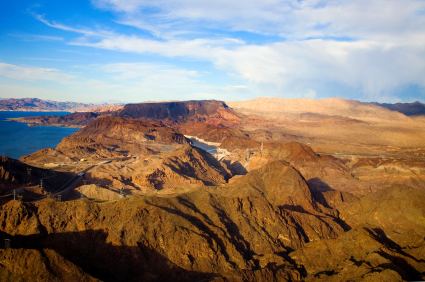
Fortification Hill is a prominence adjacent Lake Mead in the Lake Mead National Recreation Area; it is located at the northwest terminus region of the Black Mountains (Arizona), and specifically the north region of the Black Mountains. It is near a southern section of Lake Mead, and just northeast of Hoover Dam. It can easily be seen eastward across Las Vegas Bay or from the two northern mountain terminuses of Eldorado Mountains (Nevada), or the Black Mountains (Arizona).
Map of Fortification Hill, Arizona 86443, USA
The mountain prominence is plateau-like, or mesa-like with its highpoint at the southeast terminus, and sloping north and northwestwards toward Lake Mead. The prominence is 3,719 feet (1,134 m).
The flat mountaintop, sloping northwards is composed of Tertiary basaltic lava flows.