
Population 0 | ||
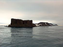 | ||
Fort William Point is the conspicuous flat-topped rocky headland forming the northwest extremity of Coppermine Peninsula and Robert Island in the South Shetland Islands, Antarctica. The point is a northwest entrance point of English Strait and forms the west side of the entrance to Carlota Cove.
Contents
Map of Fort William, Antarctica
The feature was named by the early 19th century sealers who used it as a landmark for entering English Strait from the north.
Location
The point is located at 62°22′13″S 59°43′33″W which is 7.2 km (4.5 mi) southwest of Catharina Point, 8.18 km (5.08 mi) north of Spark Point, 3.67 km (2.28 mi) north-northeast of Barrientos Island, 1.82 km (1.13 mi) east of Okol Rocks and 4.74 km (2.95 mi) southeast of Table Island (British mapping in 1821, 1962 and 1968, Argentine in 1949, Soviet Union in 1961, Chilean in 1974, and Bulgarian in 2009).