
 | ||
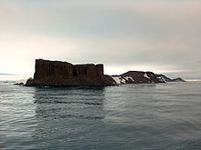
Coppermine Peninsula is the 1.7 km long, 500 m wide and rising to 105 m rugged rocky promontory forming the northwest extremity of Alfatar Peninsula and Robert Island in the South Shetland Islands, Antarctica and lying between English Strait to the west and Carlota Cove to the east. It is linked to Alfatar Peninsula to the southeast by a narrow isthmus bounded by Carlota Cove to the north and the 1 km wide and 460 m indenting Coppermine Cove (62°22′54″S 59°41′53″W) to the south. The feature is named in association with the adjacent Coppermine Cove, a descriptive name given by sealers in about 1821 from the copper-coloured staining of the lavas and tuffs in the area.
Contents
Antarctic Specially Protected Area
The Coppermine Peninsula has a regime of special environmental protection under the Antarctic Treaty System. All land west of a north-south line across the isthmus between Carlota Cove and Coppermine Cove, has been designated an Antarctic Specially Protected Area (ASPA 112, formerly SPA 16). The area is biologically rich, supporting a wide range of plant communities with associated invertebrate fauna. An exceptional feature of the vegetation is a 1.5 ha closed carpet of the mosses Calliergon sarmentosum, Calliergidium austro-stramineum and Drepanocladus uncinatus, overlying a thick layer of wet moss peat. It is one of the largest continuous stands of moss in the Antarctic. There are large numbers of bryophytes and lichens as well as Antarctic hair grass. Birds breeding at the site include chinstrap penguins, southern giant petrels, Wilson's storm petrels Antarctic terns, kelp gulls and brown skuas. The isthmus is a haul-out site for southern elephant seals, Weddell seals and Antarctic fur seals.