
Time zone +5 (UTC+5) Population 5,559 (2016) | Area 54.5 km² Local time Wednesday 11:25 AM | |
 | ||
Weather 9°C, Wind SE at 27 km/h, 35% Humidity | ||
Fort Shevchenko (Kazakh: Форт-Шевченко) is a military-base town and administrative centre of Tupkaragan District in Mangystau Region of Kazakhstan on the eastern shore of Caspian Sea. Primary industries include fishing and the extraction of stone. Population: 5,559 (2016 estimate).
Contents
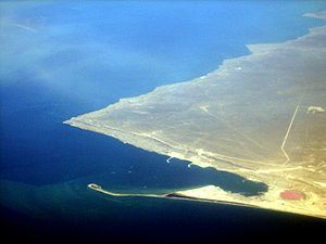
- Map of Fort Shevchenko Kazakhstan
- Fort shevchenko construction project kashagan of artificial islands in caspian sea
- History
- Russian Civil War
- Landmarks
- References
Map of Fort-Shevchenko, Kazakhstan
Fort shevchenko construction project kashagan of artificial islands in caspian sea
History
The city was founded as a military stronghold by the Imperial Russian Navy. Until 1857 it was known as Novopetrovskoye (Новопетровское) and from 1857-1939 as Fort Alexandrovsky (Форт-Александровский). It was named for Ukrainian poet Taras Shevchenko, who was assigned to military service here during his exile. Today the town is used by the Kazakhstan Navy as a base.
The coat of arms of Fort Alexandrovsky was approved October 22, 1908, along with other arms of the Transcaspian field: It is black and silver depicting the fortress and two fish.
Russian Civil War
Fort Alexandrovsky was the site of naval action on 21 May 1919, when a Squadron of the British Caspian Flotilla attacked the port.
Landmarks
There are several landmarks of significance; Shevchenko Memorial Museum, National History, and ethnographic museums. The Shevchenko Memorial Museum opened in 1932 near where he had been hiding. There are also some remnants of the fortress, a monument to Shevchenko and a state grave of Civil War heroes.
31 km from the city is the necropolis Beysenbay and up the coast the site Bautino (Баутино).