
Location Cape Verde Criteria ii, iii, vi UNESCO region Africa | Type Cultural Reference 1310 UNESCO World Heritage Site inscription 2009 | |
 | ||
Address National Highway, Cidade Vehla, Cape Verde Similar Pico da Antónia, Serra da Malagueta, Estádio da Várzea, Museu da Tabanka, Farol de D Maria Pia | ||
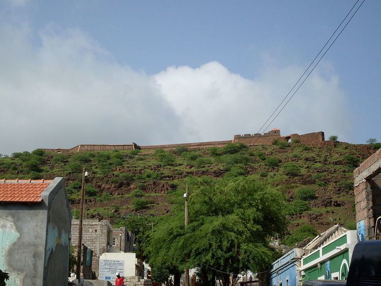
Forte (or Fortaleza) Real de São Filipe or simply Cidadela is an abandoned fort located in the city of Cidade Velha in the south of the island of Santiago, Cape Verde, it is situated on Achada de São Filipe in which the fort is named after.
Contents
It is located 120 meters above sea level, it was the first fortification in Cape Verde and is the most important. The fort offered a system of defense and protection to the city and consisted of lesser forts including Forte de Presídio located near the beach, Forte de Santo António (St. Anthony), Forte de São João dos Cavaleiros (Knights of Saint John) and Forte de São Veríssimo, it had two batteries, one in the west in Forte de São Brás (St. Blas) and Forte de São Lourenço (St. Anthony).
The fort overlooks Ribeira Grande de Santiago on the left, the city, the surrounding countryside and the nearby southern mountains of the island.
History
Located in an isolated location along the Atlantic, the settlement of Ribeira Grande had no defense before The fort plans began during the Philippine Dynasty in November 17, 1585 after assaults by English corsair Sir Francis Drake (as part of the Capture of Santiago) with a work to defend the city from pirates. Work started n 1587 and finished in 1593 in charge by the military engineer João Nunes and traces by architect Filippo Terzi.
In 1712, the city and fort was ruined by French corsairs commanded by Jacques Cassard in the Cassard expedition. It was rebuilt in the mid 18th century.
Restorations were made starting in the 20th century, between 1968 and 1970 and recently in 1999. The recent one was recorded in a renovating plan of Cidade Velha in 2000 which was started by the Cape Verdean Ministry of Culture under the coordination of the Portuguese architect Siza Vieira with resources responsible by the Spanish International Cooperation Agency.
Archeological excavations were recently done in the older barracks and the captain general's house.
Along with the fort, the city became an UNESCO World Heritage Site, one of the first in Cape Verde on June 26, 2009.
About the fortress
The fortress is built in a trapezoidal form with walls out of stone, fully diagonal bastions and vertices in east and west separated by curtains and two half-bastions in the north and south with its watchtowers. In the northwest, the wall with 480 palms high was used for defense.
The front of the fort has two doors: the main located in the southwest wall facing the city to the southwest. The lower part of the wall was used as a governor's house (around the south bastion and close to São Gonçalo (St. Gunnar) chapel. In the embankment close to the center, it had a cistern. The square part once featured 18 caliber artilleries.
The defensive buildings which divided the fort into seven fortresses, they include:
Depictions
Between 2000 and 2007, the fortress was featured on a Cape Verdean $5000 escudo bank note.