
Basin countries United States Area 16.19 km² Lake type Reservoir | Primary inflows Surface area 4,000 acres (1,600 ha) Surface elevation 409 m | |
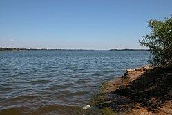 | ||
Fort Cobb Reservoir is a reservoir located in Caddo County in the U.S. state of Oklahoma. It impounds the waters of Cobb (Pond) Creek and Lake Creek. The lake covers approximately 4,000 acres (16 km²) of water and 45 mi (72 km) of shoreline. It was constructed in 1958. The towns of Carnegie, Fort Cobb, and Eakly are located nearby.
Contents
Map of Fort Cobb Reservoir, Oklahoma 73038, USA
Fort Cobb Dam is on Cobb Creek about 5 miles (8 km) north of Fort Cobb, and roughly 5 miles (8.0 km) above the confluence of Cobb Creek with the Washita River. The dam is a zoned earthfill structure containing 3,569,185 cubic yards (2,729,000 m³) of embankment. The crest width is 30 feet (9 m), and the crest length is 9,900 feet (3 km). The structural height of the dam is 122 feet (37 m).
Fort Cobb Reservoir has a total capacity of 143,740 acre feet (177,300,000 m3) and covers an area of 5,956 acres (24.1 km²) at top of flood pool level. The uncontrolled morning-glory spillway in the left abutment consists of a concrete intake structure, concrete conduit, and concrete chute and stilling basin.
The Fort Cobb Reservoir is part of the Washita Basin Project of the Bureau of Reclamation, which also includes Foss Reservoir on the Washita River in Custer County, along with numerous small flood-control structures on creeks and streams. Municipal and industrial water is supplied to the city of Anadarko and Western Farmers Electric Cooperative through the Anadarko Aqueduct which begins at the Fort Cobb Reservoir.
Recreation and fish and wildlifeEdit
Fort Cobb Reservoir provides over 2,000 acres (8 km²) of land and some 2,300 acres (9.3 km²) of water surface areas for recreation and includes 1,800 acres (7.3 km²) of land and 1,800 acres (7.3 km²) of water surface area for wildlife management. This reservoir provides some 45 mi (72 km) of shoreline at top of conservation pool. The recreation areas are administered by the Oklahoma Tourism and Recreation Department and the wildlife management area is administered by the Oklahoma Department of Wildlife Conservation. Since reservoir releases are primarily for municipal and industrial demands and flood control, the reservoir does not normally experience drastic drawdowns.
The primary fish species include white and smallmouth bass, channel catfish, walleye, bluegill, bullhead, saugeye and crappie.
The lake offers five improved camping areas located on both the north and south sides. There are also many unimproved primitive camping sites located throughout the state park and wildlife management areas of the lake.