
Country Canada Census division 16 Settled 1788 Elevation 221 m Population 847 (2011) Local time Tuesday 7:12 PM | Specialized municipality RM of Wood Buffalo Time zone MST (UTC−7) Area 10.24 km² Province Alberta Mayor Melissa Blake | |
 | ||
Weather -3°C, Wind NE at 18 km/h, 61% Humidity | ||
Fort chipewyan
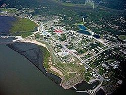
Fort Chipewyan /ˈtʃɪpəwaɪən, -pwaɪ-/, commonly referred to as Fort Chip, is a hamlet in northern Alberta, Canada, within the Regional Municipality (RM) of Wood Buffalo. It is located on the western tip of Lake Athabasca, adjacent to Wood Buffalo National Park, approximately 223 kilometres (139 mi) north of Fort McMurray.
Contents
- Fort chipewyan
- Map of Fort Chipewyan AB Canada
- My first trip to fort chipewyan alberta
- History
- Historic sites
- Demographics
- Air
- Water
- Road
- Climate
- References
Map of Fort Chipewyan, AB, Canada
My first trip to fort chipewyan alberta
History
Fort Chipewyan is one of the oldest European settlements in the Province of Alberta. It was established as a trading post by Peter Pond of the North West Company in 1788. The fort was named after the Chipewyan people living in the area.
One of the establishers of the fort, Roderick Mackenzie of Terrebonne, always had a taste for literature, as was seen years later when he opened correspondence with traders all over the north and west, asking for descriptions of scenery, adventure, folklore and history. He also had in view the founding of a library at the fort, which would not be only for the immediate residents of Fort Chipewyan, but for traders and clerks of the whole region tributary to Lake Athabasca, so that it would be what he called, in an imaginative and somewhat jocular vein, "the little Athens of the Arctic regions." This library, built in 1790, held over 2000 books, and became one of the most famous in the whole extent of Rupert's Land.
From about 1815 to 1821 the Hudson's Bay Company (HBC) maintained a competing Fort Wedderburn (named after Andrew Colvile's family) on Coal Island a mile and a half from the North West Company's fort. This fort was established by John Clarke, and Sir George Simpson arrived here in 1820-1821, where he began to reorganize the fur trade.
Sir John Franklin set out from Fort Chipewyan on his overland Arctic journey on 1820. In 1887 - 1888 there was a great famine. Electric lights did not arrive in Fort Chipewyan until 1959.
Historic sites
Old Fort Point, the site of the first Fort Chipewyan established in 1788 by Roderick Mackenzie, southeast of Fort Chipewyan was designated a National Historic Site of Canada in 1930. Historic places in the community include the site of the third Fort Chipewyan established in 1803, the Anglican Church built in 1880 and Day School built in 1874, and the Roman Catholic Mission Church built in 1909.
Demographics
As a designated place in the 2016 Census of Population conducted by Statistics Canada, Fort Chipewyan recorded a population of 852 living in 295 of its 372 total private dwellings, a change of 6999600000000000000♠0.6% from its 2011 population of 847. With a land area of 10.7 km2 (4.1 sq mi), it had a population density of 79.6/km2 (206.2/sq mi) in 2016.
The population of Fort Chipewyan in 2012 was 1,008 according to a municipal census conducted by the R.M of Wood Buffalo.
As a designated place in the 2011 Census, Fort Chipewyan had a population of 847 living in 302 of its 358 total dwellings, a 12% change from its 2006 population of 756. With a land area of 10.23 km2 (3.95 sq mi), it had a population density of 82.80/km2 (214.44/sq mi) in 2011.
The hamlet's population is predominantly made up of Cree First Nations, Chipewyan (Dene) First Nations, and Metis people.
Air
The hamlet is served by the Fort Chipewyan Airport, opened on June 18, 1966. Air is one of two methods of access to Fort Chipewyan in the summer.
Water
In the summer, the hamlet also can be accessed by boat from Fort McMurray via the Athabasca River.
Road
There are no all-weather roads to Fort Chipewyan, but it can be reached via winter roads in the winter. These include roads from Fort Smith to the north and from Fort McMurray to the south. Although the Alberta government has previously conducted studies on all-weather road access, no action has been taken. In December 2005, one-third of Fort Chipewyan's residents signed a petition to request the government to build a 50 km (31 mi) all-weather road to connect with existing roads to the northwest that provide access to Fort Smith, Northwest Territories. The major expenditure would be a bridge over the Slave River.
Climate
Fort Chipewyan has a subarctic climate (Köppen Dfc) with long, very cold, dry winters and short, warm, wetter summers. The highest temperature ever recorded in Fort Chipewyan was 34.7 °C (94.5 °F) on 27 June 2002. The coldest temperature ever recorded was −51.1 °C (−60 °F) on 1 February 1917.