
Existed: 1988 – present Length 12.6 km | North end: Alt. US 90 in Houston Constructed 1988 | |
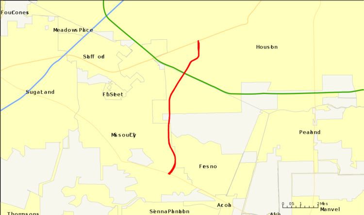 | ||
South end: Sienna Parkway in Missouri City | ||
The Fort Bend Parkway Toll Road is the Fort Bend County (i.e.,southern) portion of a continuous toll road connecting Sienna Plantation in eastern Fort Bend County to US 90A in southwestern Harris County. It is administered by the Fort Bend County Toll Road Authority (FBCTRA). The Harris County Toll Road Authority (HCTRA) administers the Harris County (i.e., northern) segment of the road — from just south of Beltway 8 at the county line to US 90A — and uses its purple pentagonal shield labeled as Fort Bend Toll Road (the colloquial name for the entirety). It is proposed to reach a northern terminus at the southwestern corner of Interstate 610 in the future, and SH 99 at its southern terminus.
Contents
- Map of Fort Bend Parkway Toll Rd Texas USA
- History and formation
- History of SH 122
- Signage and designation
- Exit list
- References
Map of Fort Bend Parkway Toll Rd, Texas, USA
The toll road has two lanes in each direction with major interchanges at Sienna Parkway, State Highway 6, Lake Olympia Parkway, and FM 2234, and a connection, albeit not seamless, with Beltway 8. There are Toll Plazas between every interchange in FBCTRA territory. Originally, a main toll plaza was located north of FM 2234 with ramp tollbooths at FM 2234 and Lake Olympia Parkway. There is another toll plaza located north of Beltway 8 in the HCTRA segment. The speed limit is 65 mph in the southern portion but drops to 60 mph inside Beltway 8.
The cost for the toll road is estimated between $55 million and $60 million.
History and formation
The tollway's origins date back to a TxDOT (Texas Department of Transportation) original proposal of building a highway from the southwest corner of Loop 610 in Houston (where North Braeswood and 610 meet). A section of frontage roads (later part of Hillcroft Avenue in Houston) was constructed in the late 1960s/early 1970s (date unknown) south of the proposed Beltway 8 (Sam Houston Tollway), south of Harris County adjacent to the Chasewood and Willow Park II subdivisions in northeast Fort Bend County.
Originally planned as either the West Loop Extension or the Bay City Freeway, the proposed freeway was cancelled in 1979 although remnants of the freeway exist (an extension of South Post Oak between West Bellfort and North/South Braeswood, along with a section of the Fort Bend Tollway between Beltway 8 and West Fuqua in Fort Bend County). Although the 1979 cancellation has ended TxDOT's highway proposal, Fort Bend County had an interest in the roadway project since 1984. On March 29, 1988, the parkway was officially designated by TxDOT as State Highway 122—stretching from Beltway 8 to the Grand Parkway (SH 99). Environmental and feasibility studies were conducted during the next 10 years.
In November 2000, citizens of Fort Bend County approved a $140 million bond issue to support revenue bond financing for construction of the Parkway and Westpark projects. After fulfilling prudent feasibility studies and careful planning, Fort Bend County Toll Road Authority (FBCTRA) broke ground and began the construction phase in July 2003. The Fort Bend Parkway Toll Road opened August 30, 2004.
Harris County Commissioners' Court approved an approximate five-mile (8 km) extension of the proposed Fort Bend Parkway Toll Road project. While the primary corridor was constructed by the Fort Bend County Toll Road Authority, the extension was built by the Harris County Toll Road Authority and provides a connection from the Fort Bend County line at Beltway 8 to, currently, US Highway 90A, and in the future to the existing Post Oak Road at West Bellfort—near the southwest corner of the 610 Loop.
In 2006, the State Highway 122 designation was removed from the section north of State Highway 6.
In July 2008, cash collection was discontinued on the Fort Bend Parkway Toll Road (maintained by FBCTRA). The only valid payments on this portion of the toll road are either HCTRA's EZ TAG, NTTA's TollTag, or TxTAG. In 2015, FBCTRA replaced the Plazas and repositioned them to be on the road between interchanges. Cash collection (in the form of exact change) continues on the HCTRA maintained segment, the Fort Bend Toll Road.
On March 31, 2014, the FBCTRA opened a 1.8 mile, four-lane southern extension of the Fort Bend Parkway Toll Road to Sienna Parkway. FBCTRA began construction on an overpass over Hwy 6 in February 2015 and opened in March 2017.
History of SH 122
SH 122 was a highway proposed by 1928 to go from Cleburne to Weatherford. That route was replaced by SH 171 in 1939.
Signage and designation
The name of the road and its signage change along its route:
Although the Fort Bend Toll Road (Harris County) and the Fort Bend Parkway Toll Road (Fort Bend County) connect as one contiguous route, each is signed as a separate route. State Highway 122 existed as a placeholder for TxDOT in case it was decided to use state funding to build the toll road.
Exit list
All exits are unnumbered.
The proposed SH 122 would extend from SH 6 to the planned segment of SH 99 that will be built to the south. In the future, South Post Oak Road/Chimney Rock Road will be a part of the Fort Bend Parkway Tollway.