
Nearest city Cox, Georgia Built by Baillie,Lt. Robert Opened 1760 Added to NRHP 27 September 1972 | Built 1760 NRHP Reference # 72001447 Area 4 ha | |
 | ||
Similar Fort King George, Fort Morris, Bartram's Garden, Savannah River | ||
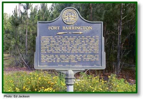
Fort Barrington, renamed Fort Howe during the American Revolutionary War, was a fort in Georgia. It was added to the National Register of Historic Places on September 27, 1972. The fort is located on the Altamaha River, northwest of Cox, Georgia, near Sansavilla.
Contents
It was also a strategic location during the War of 1812.
Fish camp 2015 fort barrington
History
The fort was used by the British from 1751 until the 1780s, first in defense from the Spaniards and Indians, and then during the Revolutionary War. It changed hands during the Revolutionary War. It was used during the American Civil War. A historical marker for the site is located on Georgia State Route 57 at the Long County - McIntosh County line. There are no remains.
The site is not officially historical because the land, and the land around it is owned by a club and officials cannot access it because of that. The owners of the land just bought more of land around it because of people trespassing on the land to see the site. During the fort's time a big thick metal line was across the river the pull a boat across the river. The line now rests at the bottom of the river. Many pieces can be found from the fort like bricks, bullets, arrow heads, and little defensive sites in the area around it. Many pieces can be found around the site.