
Official name Fontana Dam Height 146 m Length 721 m Construction began 1 January 1942 | Opening date November 7, 1944 Opened 7 November 1944 | |
 | ||
Total capacity 1,443,000 acre feet (1.780 km) Similar Clingmans Dome, Shuckstack, Cheoah Dam, Great Smoky Mountain, Great Smoky Mountain | ||
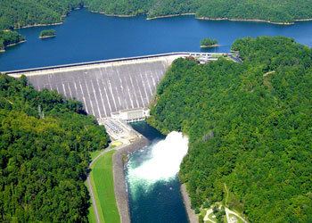
Fontana dam and cheoah dam spilling over jan 2016
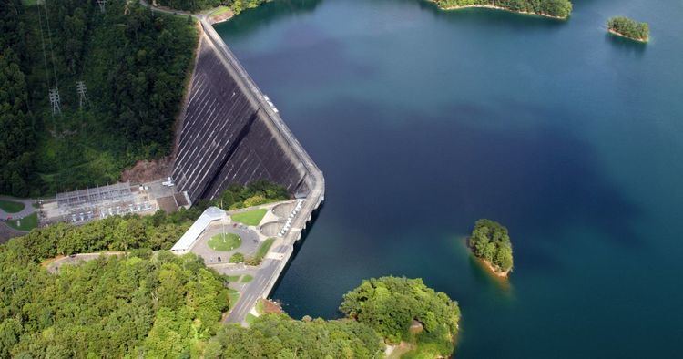
Fontana Dam is a hydroelectric dam on the Little Tennessee River in Swain and Graham counties, North Carolina, United States. The dam is operated by the Tennessee Valley Authority, which built the dam in the early 1940s to accommodate the skyrocketing electricity demands in the Tennessee Valley at the height of World War II. At 480 feet (150 m) high, Fontana is the tallest dam in the Eastern United States, and at the time of its construction, it was the fourth tallest dam in the world.
Contents
- Fontana dam and cheoah dam spilling over jan 2016
- Fontana dam project
- LocationEdit
- CapacityEdit
- Background and constructionEdit
- North Shore Road controversyEdit
- Incline TramEdit
- References
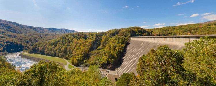
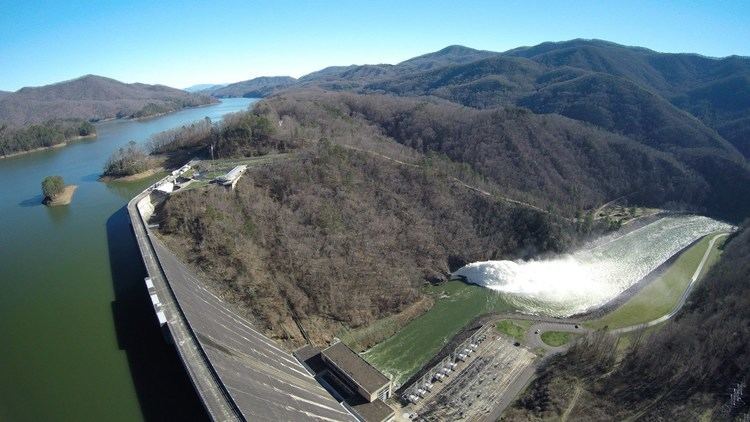
The dam impounds the 10,230-acre (4,140 ha) Fontana Lake, which spreads across a scenic stretch of the Little Tennessee along the southwestern boundary of the Great Smoky Mountains National Park. The Appalachian Trail crosses the top of the dam. Fontana is named for the now-inundated town of Fontana, a lumber and copper-mining hub once located at the mouth of Eagle Creek. The town's name was derived from the Italian word for "fountain."
Fontana dam project
LocationEdit
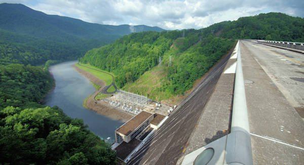
The Little Tennessee River flows for 135 miles (217 km) from its source in the mountains of northern Georgia to its mouth along the Tennessee River opposite Lenoir City, Tennessee. Fontana is located 61 miles (98 km) above the mouth of the Little Tennessee, in a remote area where the westward-flowing river bends briefly to the south. Fontana Dam is a 30-mile (48 km) drive from the three nearest cities — Maryville, Tennessee to the west, Bryson City, North Carolina to the east, and Robbinsville, North Carolina, to the south, although the small resort of Fontana Village (which has its roots as the temporary village where many of the workers constructing the dam were housed) has developed just south of the dam. The Great Smoky Mountains rise to the north and the Yellow Creek Mountains (mostly protected by the Nantahala National Forest) rise to the south. Fontana is the uppermost of five dams on the Little Tennessee River, with Cheoah Dam being 10 miles (16 km) downstream, followed by Calderwood Dam, Chilhowee Dam, and Tellico Dam.
Along with a 29-mile (47 km) stretch of the Little Tennessee, Fontana Lake also extends across the lower 11 miles (18 km) of the Tuckasegee River (which flows southward from Cherokee and Bryson City) and the lower 5 miles (8.0 km) or so of the Nantahala River, extending into the scenic Nantahala Gorge. Several rapid-flowing mountain streams— some of which drop several thousand feet from the crest of the Great Smokies in just a few miles— empty into Fontana's north shore. The most notable of these streams — Eagle Creek and Hazel Creek — form substantial embayments just upstream from the dam.
North Carolina Highway 28 (which crosses a bridge downstream from the dam) provides the only major road access to the Fontana Dam area. At Deals Gap, 11 miles (18 km) west of the dam, the road intersects U.S. Route 129, which then continues westward to Maryville. East of the dam, NC-28 follows the lake's south shore for about 25 miles (40 km) before intersecting U.S. Route 74. As part of the Fontana Project, the National Park Service agreed to build a road along the lake's north shore, connecting the dam directly to Bryson City, although due to financial issues and environmental concerns this road was never completed, and remains one of the Fontana project's most enduring controversies.
CapacityEdit
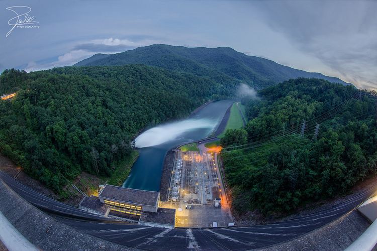
Fontana Dam is 2,365 feet (721 m) long and 480 feet (146 m) high, making it the tallest dam in the Eastern United States. The dam has a flood storage capacity of 513,965 acre feet (633,966,000 m3), and the combined capacity of its three generators is 293.6 megawatts. Fontana Lake has 238 miles (383 km) of shoreline and 10,230 acres (4,140 ha) of water surface, and its surface elevation varies by 57 feet (17 m) annually.
Background and constructionEdit
The Aluminum Company of America (Alcoa) began investigating the Little Tennessee Valley around 1910 in hopes of finding a power source for the massive amounts of electricity needed at its aluminum production operations at nearby Alcoa, Tennessee. In 1913, ALCOA purchased the Tallassee Power Company (now Tapoco), and by 1930 the two entities had completed Cheoah and Calderwood dams, as well as Santeetlah Dam on the Cheoah River. By the mid-1930s, ALCOA had assessed the Fontana site and had purchased the initial 15,000 acres (6,100 ha) for the dam's construction.
In 1935, the Tennessee Valley Authority, which was concerned with the Little Tennessee's effect on flood control in the greater Tennessee Valley, began negotiating with ALCOA to assume control of the Fontana project. Although ALCOA preferred TVA build the dam, TVA was unable to get necessary funding for the project until the outbreak of World War II in 1941, when emergency wartime initiatives called for a drastic increase in aluminum production. On August 14, 1941, TVA and ALCOA signed the "Fontana Agreement," which gave TVA possession of Fontana and control over the releases and output of Tapoco's Little Tennessee Valley dams, and in return guaranteed that ALCOA would be the primary benefactor of the dams' electrical output for at least twenty years. Congress authorized funding on December 17, 1941, and construction of Fontana Dam began on January 1, 1942.
The building of Fontana Dam and its reservoir required the purchase of 68,292 acres (27,637 ha) of land, 5,125 acres (2,074 ha) of which were forested and had to be cleared. 1,311 families, 1,047 graves, and over 60 miles (97 km) of roads had to be relocated. The towns of Fontana, Bushnell, Forney, and Judson were completely inundated. The village of Welch Cove (later renamed Fontana Village) was constructed just south of the dam to house the project's workers, whose numbers had reached 5,000 by 1943 in spite of nationwide manpower shortages. Fontana Village is now a summer resort and still has some of the original buildings.
The design of the dam was unusual for TVA at the time. It was feared that the 2,818,000 yd³ (2,155,000 m³) of concrete required for the dam would create a structure so massive, that heat released during its setting would be trapped for years, and would eventually cause cracks to form. To aid the release of this heat, engineers divided the dam into contraction joints and outfitted them with grout pipes and cooling coils. The dam's spillway presented another problem, as engineers were worried that the water's 400-foot (120 m) drop would eventually cause erosion issues at the dam's foundation. A special spillway was thus designed that drains water out through two 34-foot (10.3 m) diameter spill pipes into a diversion tunnel equipped with a deflection system. The dam's design is largely the work of TVA Chief Architect Roland Wank.
Fontana Dam was completed at a cost of $70,420,688.48 and the gates closed on November 11, 1944. Two generating units were placed in operation on January 20, 1945, in time to provide crucial energy for aluminum production in the closing months of World War II. Over 40,000 acres (16,000 ha) along Fontana Lake's north shore were eventually transferred to the Great Smoky Mountains National Park, and several thousand acres along the south shore were transferred to the U.S. Forest Service.
North Shore Road controversyEdit
The construction of Fontana Dam led to the flooding of most of North Carolina Highway 288, which connected Deals Gap and Bryson City. The National Park Service, after gaining possession of Fontana's north shore tracts, reached an agreement with Swain County to replace the north shore road in the 1940s. By 1972, however, environmental concerns and funding issues had continuously stalled construction, and just 7.2 miles (11.6 km) of the road had been completed (just outside Bryson City). In the 1970s, environmental concerns completely halted the road's progress, and locals nicknamed the unfinished road "The Road to Nowhere". After North Carolina's U.S. Senator Jesse Helms secured funding for the road in 2000, the park service conducted an environmental impact study (released in 2007) and concluded that the road's construction would cause "major, adverse, long-term impacts to topography, geology, and soils" in the area. Proponents of the road argued that the environmental concerns were exaggerated. In 2007, Swain County accepted a $52 million cash settlement from the park service, and agreed to drop its demand for a new road along the North Shore.
As of September 2014, Swain County has received $12.2 million of the money. A House bill introduced by Mark Meadows in December 2013 and a Senate bill introduced by Kay Hagan in July 2014 require the National Park Service to include $4 million in settlement money in its construction budget.
Incline TramEdit
The Fontana Dam site previously hosted a 800 mm (2 ft 7 1⁄2 in) narrow gauge funicular railway for tourists.