
Length 53.76 km | ||
 | ||
East end: US 98 / US 301 in Dade City | ||
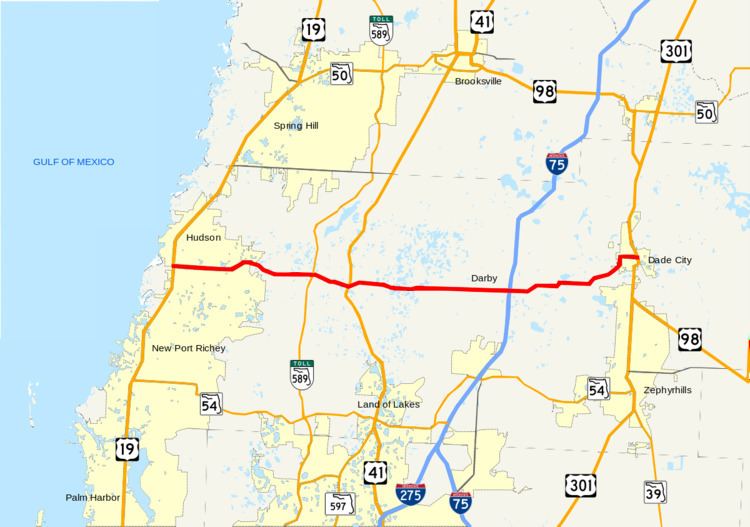
State Road 52 (SR 52) is the major east–west road through northern Pasco County, Florida. The road begins in Bayonet Point at US 19 (SR 55), passes through San Antonio, runs past Saint Leo University, in Saint Leo, and terminates in Dade City at US 98 / US 301 (SR 533).
Contents
Map of FL-52, Florida, USA
Route description
State Road 52 exists primarily as a six-lane commercial strip between US 19 and Moon Lake Road. In 2007, the road was widened to six lanes between Moon Lake Road and Suncoast Parkway, but most of the development taking place here has been residential so far. On the Southeast corner of the Suncoast Parkway interchange, there is a Florida State Police barracks and Florida Division of Forestry fire tower. The road narrows down to four lanes and then two as it enters Fivay Junction and approaches Shady Hills Road, before crossing the Pithlachascotee River. As the road runs along the north side of some agricultural land, it eventually meets with a railroad crossing, and then passes a saw mill before encountering US 41 (SR 45) at a section of Pasco County which is known as Gowers Corner. Plans to widen SR 52 in the vicinity of US 41 include the realignment of both roads.
East of US 41 is a community known as the Pilot Country Estates Airport, where residents have their own private airplanes. Beyond that, most of the features surrounding SR 52 consist of fledgling farmland and minor lakes. At least one other gated community exists east of this point. Other sites along this segment include the Dirt Devil's Speedway and a concrete factory on the southwest corner of CR 583 (Ehren Cutoff). A winery was established at some point in the early 21st Century and a model aviation club existed in one of two locations along this segment of the road.
After a pair of bridges over two dry creeks, SR 52 encounters Bellamy Brothers Boulevard (CR 581 North), which leads drivers north through farms and woods before entering the City of Brooksville. Meanwhile, SR 52 climbs a hill and then drops before approaching the Pasco County Juvenile Detention Center. Almost immediately, the road enters the unincorporated hamlet of Pasco as it crosses a former railroad right-of-way that once ran from St. Petersburg to Trilby. The interchange with Interstate 75 (Exit 285) is easily in view of motorists before reaching the former grade crossing, but not without approaching a gated community and two truck stops.
Immediately after the I-75 interchange, SR 52 passes by and industrial park and Recreational Vehicle dealership, then curves to the northeast as it crosses another dry creek bridge. The road turns back east as it enters San Antonio and instantly makes a direct left curve into Saint Leo. The north-to-eastbound ramp takes drivers though the St. Leo Abbey Historic District and Saint Leo University on a steep hill.
Between CR 579 and Alternate CR 35, there's an CR 52 Alternate along Clinton Avenue south of State Road 52 that has no direct connection to the main road. Immediately after the CR 579 intersection, the road takes another sharp northeast curve, and despite a sharp curve back to the right, continues to move to the northeast.
After SR 52 enters the Dade City Limits, it runs along the northwestern border of Pasco High School, until the intersection of Old San Ann Drive and moves north onto 21st Street. Eventually, County Road 41 replaces SR 52 as the designation for 21st Street when it makes a sharp right onto Meridian Avenue, but eastbound SR 52 and southbound CR 41 overlap each other until 17th Street, where CR 41 turns south unexpectedly. As the road divides again east of 10th Street, drivers truly enter the heart of Dade City when they encounter local parkland that was once part of a Seaboard Air Line right-of-way, and then intersects 7th Street (former US 98-301), where the historic Pasco County Courthouse can be found on the southeast corner. After passing by more local government buildings including the Dade City Branch of the Pasco County Library, State Road 52 ends at US 98-301 on the opposite side of the Dade City Atlantic Coast Line Railroad Depot. This was a Truck Detour for US 98-301 until February 2007.
History
Former segments of State Road 52, have included Roth Lane, in Saint Leo, and North 21st Street and Lock Street in Dade City.
Major intersections
The entire route is in Pasco County.
Related route
County Road 52 Alternate is the bannered route of SR 52 south of Dade City. It begins at County Road 579 just south of the intersection with SR 52, and runs east along Clinton Street.