
Population 715 (2011) Local time Monday 4:18 AM | OS grid reference ST505695 Region South West Sovereign state United Kingdom Dialling code 01275 | |
 | ||
Weather 5°C, Wind W at 8 km/h, 91% Humidity | ||
Flax Bourton is a village and civil parish in Somerset, England. The parish, with a population of 715, is situated within the Unitary Authority of North Somerset, on the edge of Nailsea Moor on the A370 road 5 miles (8.0 km) south west of Bristol city centre.
Contents
- Map of Flax Bourton Bristol UK
- History
- Governance
- Geography
- Transport
- Religious sites
- Notable residents
- Famous people
- References
Map of Flax Bourton, Bristol, UK
The village has a primary school, one pub named The Jubilee Inn, a church dating back to Norman times and is the home of Backwell Flax Bourton Cricket Club.
History
Backwell Hillfort between Flax Bourton and Backwell is an iron age hill fort.
To the north of the village and close to the Bristol to Exeter railway line a mill was built on the Land Yeo. It may have existed at the time of the Domesday Book and strong documentary evidence exists from 1769. Between 1839 and 1885 the river was diverted into the tailrace of the mill, eliminating a bend in the river. All that remains of the three storey mill is a single storey garage of a private house.
Farleigh Hospital and the Church of St. George was built in 1837 as a Workhouse for the Bedminster Union. Also on Old Weston Road is the former Long Ashton Magistrate's Court and Police Station, which was built 1857-58 by John Norton, and is now home to the Coroner's court for Bristol and North Somerset.
An MoD fuel depot, part of the Government Pipelines and Storage System with its own railway sidings, is just off the main line behind the former station. Its future is currently under review.
Governance
The parish council has responsibility for local issues, including setting an annual precept (local rate) to cover the council's operating costs and producing annual accounts for public scrutiny. The parish council evaluates local planning applications and works with the local police, district council officers, and neighbourhood watch groups on matters of crime, security, and traffic. The parish council's role also includes initiating projects for the maintenance and repair of parish facilities, such as the village hall or community centre, playing fields and playgrounds, as well as consulting with the district council on the maintenance, repair, and improvement of highways, drainage, footpaths, public transport, and street cleaning. Conservation matters (including trees and listed buildings) and environmental issues are also of interest to the council.
The parish falls within the unitary authority of North Somerset which was created in 1996, as established by the Local Government Act 1992. It provides a single tier of local government with responsibility for almost all local government functions within its area including local planning and building control, local roads, council housing, environmental health, markets and fairs, refuse collection, recycling, cemeteries, crematoria, leisure services, parks, and tourism. It is also responsible for education, social services, libraries, main roads, public transport, trading standards, waste disposal and strategic planning, although fire, police and ambulance services are provided jointly with other authorities through the Avon Fire and Rescue Service, Avon and Somerset Constabulary and the Great Western Ambulance Service.
North Somerset's area covers part of the ceremonial county of Somerset but it is administered independently of the non-metropolitan county. Its administrative headquarters is in the town hall in Weston-super-Mare. Between 1 April 1974 and 1 April 1996, it was the Woodspring district of the county of Avon. Before 1974 that the parish was part of the Long Ashton Rural District.
The parish is represented in the House of Commons of the Parliament of the United Kingdom as part of the Woodspring county constituency which is to become North Somerset at next general election. It elects one Member of Parliament (MP) by the first past the post system of election. It is also part of the South West England constituency of the European Parliament which elects seven MEPs using the d'Hondt method of party-list proportional representation.
Geography
Stancombe Quarry was first built in 1952. Today, the quarry which is operated by Tarmac, produces Carboniferous Limestone, which is mainly for use on the roads, after crushing on site. The site has an expected output of 28 million tonnes over a 25-year period.
Along with the rest of South West England, Flax Bourton has a temperate climate which is generally wetter and milder than the rest of the country.
Transport
In 1860 Flax Bourton railway station was opened by the Bristol and Exeter Railway just west of the short tunnel at the summit of the climb from Bristol. It closed to passengers on 2 December 1963. Sustrans have recently built a cycle path leading to Backwell and Nailsea, adjacent to the railway line. Today the nearest station is Nailsea and Backwell. There are also regular bus links available from Farleigh Green (to Weston Super-Mare), and top of station road (to Bristol)
Religious sites
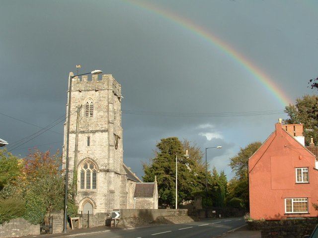
The Anglican parish church of St. Michael and All Angels has 12th-century origins and has been designated as a Grade II* listed building.