
Founded March 5, 1853 Area 2,233 km² | Website www.co.fillmore.mn.us Population 20,835 (2013) Unemployment rate 4.3% (Apr 2015) | |
 | ||
Points of interest Forestville Mystery Cave Stat, Niagara Cave, Historic Forestville, Peterson Station Museum, Mystery Cave State Park Destinations | ||
Fillmore County is a county located in the U.S. state of Minnesota. As of the 2010 census, the population was 20,866. Its county seat is Preston.
Contents
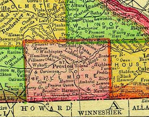
Map of Fillmore County, MN, USA
Fillmore County is included in the Rochester, MN Metropolitan Statistical Area.
History
Fillmore County was established in 1853. It is named for Millard Fillmore, thirteenth President of the United States. Located in Southeast Minnesota, Fillmore County was an early destination for Euro-American settlement following the United States' 1851 treaties with the Dakota nations. Norwegian immigrants were particularly numerous. In 1860 Fillmore was the most populous county in Minnesota.
Geography
According to the U.S. Census Bureau, the county has a total area of 862 square miles (2,230 km2), of which 861 square miles (2,230 km2) is land and 0.8 square miles (2.1 km2) (0.09%) is water.
The county is part of the Driftless Area, or in its own documents, the Paleozoic plateau. This part of Minnesota was ice-free during the last ice age. The county to the east is more rugged, but Fillmore County also displays a karst topography.
Adjacent counties
Demographics
As of the census of 2000, there were 21,122 people, 8,228 households, and 5,718 families residing in the county. The population density was 24 people per square mile (9/km²). There were 8,908 housing units at an average density of 10 per square mile (4/km²). The racial makeup of the county was 98.92% White, 0.17% Black or African American, 0.10% Native American, 0.15% Asian, 0.17% from other races, and 0.49% from two or more races. 0.53% of the population were Hispanic or Latino of any race. 39.9% were of Norwegian, 31.1% German and 5.8% Irish ancestry.
There were 8,228 households out of which 30.90% had children under the age of 18 living with them, 60.60% were married couples living together, 6.10% had a female householder with no husband present, and 30.50% were non-families. 26.60% of all households were made up of individuals and 14.00% had someone living alone who was 65 years of age or older. The average household size was 2.50 and the average family size was 3.05.
In the county, the population was spread out with 26.10% under the age of 18, 7.00% from 18 to 24, 25.10% from 25 to 44, 22.50% from 45 to 64, and 19.40% who were 65 years of age or older. The median age was 40 years. For every 100 females there were 97.30 males. For every 100 females age 18 and over, there were 95.80 males.
The median income for a household in the county was $36,651, and the median income for a family was $44,883. Males had a median income of $29,094 versus $21,906 for females. The per capita income for the county was $17,067. About 6.80% of families and 10.10% of the population were below the poverty line, including 14.40% of those under age 18 and 11.20% of those age 65 or over.