
Population 2,942. 2011 Census Civil parish Fernhurst Area 23.37 km² Local time Saturday 1:04 AM | OS grid reference SU896284 Sovereign state United Kingdom Dialling code 01428 UK parliament constituency Chichester | |
 | ||
Weather 9°C, Wind SE at 8 km/h, 97% Humidity | ||
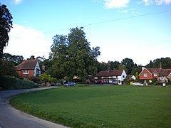
Fernhurst is a village and civil parish in the Chichester District of West Sussex, England. It is located on the A286 Guildford to Chichester road, three miles (5 km) south of Haslemere. The parish includes the settlements of Henley Common, Kingsley Green and Bell Vale and is sited within the boundaries of the South Downs National Park.
Contents
- Map of Fernhurst Haslemere UK
- History
- Governance
- St Margarets Church
- May Revels
- Verdley estate
- Notable people
- References
Map of Fernhurst, Haslemere, UK
The area of the parish is 2337 hectares (5772 acres). In the 2001 census there were 1,158 households with a total population of 2,765 of whom 1,244 were economically active. The population had increased to 2,942 at the 2011 Census.
The village is surrounded by hills, including Telegraph Hill 676 feet (206 m), Marley Heights 700 feet (210 m), Bexley Hill 600 feet (180 m), Fridays Hill 675 feet (206 m) and the highest hill in Sussex, Blackdown 919 feet (280 m) to the northeast. It is surrounded by miles of footpaths, the path to the summit of Blackdown commencing at the Red Lion.
History
The village, on the Weald, originally developed around crossroads (The Cross) and the village green, and ancient remains (Stone Age and Roman) have been found here. Iron working took place in the 17th/18th centuries; and a turnpike ran through the village. The church, dedicated to St Margaret, (c. 1100) and Red Lion pub are located here and several old houses still remain. With the coming of the railway to Haslemere the village developed around and beyond The Cross, and since the 1960s the village has expanded further westwards. The village houses a commuter population, attracted by the proximity of Haslemere railway station.
In November 2006 the Fernhurst Society published a book, "Voices of Fernhurst", comprising edited extracts of oral history interviews with local villagers.
Governance
An electoral ward in the same name exists. This ward includes Linchmere and had at the 2011 census a total ward population of 5,334.
St Margaret's Church
The Anglican parish church, dedicated to St Margaret, was rebuilt in the nineteenth century, the south aisle in 1859 and the tower and spire as part of a general restoration by Anthony Salvin in 1881. The interior is plain.
May Revels
Every May the traditional "Revels" fete is held on the green, raising funds for village societies and some local charities. The event includes various local May-time celebrations, such as maypole dancing, and the May queen is elected from the local area. In May 2006 a film of the village for the Meridian ITV programme "Village voices" was filmed involving the revels and local craftsmen. It was screened on 15 August 2006.
Verdley estate
About a mile south east of the village lies the Verdley estate. Verdley Castle, probably a 14th-century fortified manor house, or hunting tower, now demolished, lay in present day Henley Wood. Its concealed wooded location in a hollow afforded protection for smugglers bringing goods from the south coast.
Closer to the village, Verdley Place was built by architect Anthony Salvin in 1873–5, as a country house for Charles Savile Roundell. Baron Davey was living here with his wife, three daughters and a son in the 1891 census. This Grade II listed building and the surrounding estate was the home of ICI's Plant Protection Division and its predecessors from 1945 and subsequently a Zeneca research and development centre. It has since been sold and converted to a residential development.