
Country United States County Oakland Elevation 646 ft (197 m) Zip code 48220 Population 20,257 (2013) | Incorporated 1918 (village) Time zone EST (UTC-5) Local time Friday 7:54 PM Mayor David Coulter | |
 | ||
Weather -6°C, Wind NW at 21 km/h, 34% Humidity | ||
Saigon nails spa 22620 woodward ave ste b ferndale michigan 48220 1859
Ferndale is a city in Oakland County of the U.S. state of Michigan. It forms part of the Detroit metropolitan area. As of the 2010 census, the city population was 19,900.
Contents
- Saigon nails spa 22620 woodward ave ste b ferndale michigan 48220 1859
- Map of Ferndale MI 48220 USA
- Introducing john d bistro ferndale michigan interview eddie farah owner
- History
- Government
- Geography
- 2010 census
- 2000 census
- LGBT population
- Media
- Crime
- Education
- Notable people
- References
Map of Ferndale, MI 48220, USA
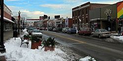
Ferndale is primarily residential, with a smaller commercial and industrial sector in the southeast part of the city. Ferndale's business district is anchored by the intersection of Woodward Avenue and 9 Mile Road, where privately owned shops, storefronts, dance clubs, bars and numerous restaurants are featured. Ferndale is well known in the Detroit area for its LGBT population and progressive policies. It is also the setting for the NBC sitcom Undateable.
Introducing john d bistro ferndale michigan interview eddie farah owner
History
Native Americans were early inhabitants of the area now known as the City of Ferndale. In the 1800s farmers began cultivating the land. After the invention of the automobile and the development of the automotive assembly line, the population of Ferndale increased rapidly.
Ferndale was incorporated into a village in 1918. It was then incorporated into a city on March 7, 1927, by vote of the citizens of the village. It became a bedroom community for Detroit workers, with most of its growth in housing from 1920-1951. Through the early 1950s there were trolley (interurban railroad) lines in the median strip of Woodward Avenue from downtown Detroit to Pontiac. These helped the northern suburbs of Detroit grow as bedroom communities as people could take the trolley to shop or work in Detroit.
In the 1970s, the Ferndale suburban community emerged as a place for families to raise children during the "Baby Boom" era, with its elementary schools, a downtown, city parks, active churches and civic groups. Ferndale High was completed in 1958.
Ferndale's downtown shopping area, 9 Mile Road, featured many busy, popular stores in the 1940s to 1960s, but later went into decline, and many business closed. In recent decades, the downtown area has revitalized. Ferndale's downtown is formed by two major thoroughfares, Nine Mile Road and Woodward Avenue. Circa 1997 the city made the downtown more pedestrian-friendly by narrowing West Nine Mile Road, the heart of the downtown, to one lane in each direction and adding on-street parking. The result has been a return of pedestrian traffic and an influx of new stores and restaurants. The city has continued to make itself more accessible to people by reducing traffic lanes on Hilton Road and Pinecrest Road, two major local north/south streets, and adding bicycle lanes.
Government
Ferndale utilizes the Council-Manager form of government,and is governed by a city council consisting of a mayor and four council members. The city council appoints a city manager, who manages the day-to-day operations of the city. The current mayor of Ferndale is Dave Coulter. Current city council members are Raylon Leaks-May, Greg Pawlica, Dan Martin and Melanie Piana, who is also Mayor Pro Tem. The current city manager is April Lynch, Ferndale's first female manager.
Geography
Ferndale is located at 42°27′40″N 83°7′44″W.
According to the United States Census Bureau, the city has a total area of 3.88 square miles (10.05 km2), all land.
Ferndale is adjacent to the cities of Detroit to the south, Oak Park to the west, Hazel Park to the east, Pleasant Ridge to the north, Royal Oak Township to the southwest, and Royal Oak to the north.
Ferndale is bordered to the south by 8 Mile Road, to the north (west of Woodward Avenue) by Oakridge Street, and (east of Woodward Avenue) by 10 Mile Road. To the west it is bordered by Republic Street (south of Nine Mile Road), and Hyland Street (north of Nine Mile). To the east it is bordered by West End, Pilgrim Street, and Lennox Street.
2010 census
As of the census of 2010, there were 19,900 people, 9,559 households, and 4,349 families residing in the city. The population density was 5,128.9 inhabitants per square mile (1,980.3/km2). There were 10,477 housing units at an average density of 2,700.3 per square mile (1,042.6/km2). The racial makeup of the city was 84.7% White, 9.6% African American, 0.5% Native American, 1.3% Asian, 0.1% Pacific Islander, 0.5% from other races, and 3.4% from two or more races. Hispanic or Latino of any race were 2.8% of the population.
There were 9,559 households of which 20.4% had children under the age of 18 living with them, 30.3% were married couples living together, 10.9% had a female householder with no husband present, 4.3% had a male householder with no wife present, and 54.5% were non-families. 39.0% of all households were made up of individuals and 6.8% had someone living alone who was 65 years of age or older. The average household size was 2.08 and the average family size was 2.85.
The median age in the city was 35.6 years. 16.5% of residents were under the age of 18; 8.3% were between the ages of 18 and 24; 41.2% were from 25 to 44; 25.2% were from 45 to 64; and 8.9% were 65 years of age or older. The gender makeup of the city was 49.9% male and 50.1% female.
2000 census
As of the census of 2000, there were 22,105 people, 9,872 households, and 5,103 families residing in the city. The population density was 5,697.9 people per square mile (2,199.7/km²). There were 10,243 housing units at an average density of 2,640.3 per square mile (1,019.3/km²). The racial makeup of the city was 91.46% White, 3.42% Black or African American, 0.55% Native American, 1.32% Asian, 0.02% Pacific Islander, 0.64% from other races, and 2.58% from two or more races. 1.81% of the population were Hispanic or Latino of any race.
There were 9,872 households out of which 23.5% had children under the age of 18 living with them, 35.8% were married couples living together, 11.5% had a female householder with no husband present, and 48.3% were non-families. 35.2% of all households were made up of individuals and 7.8% had someone living alone who was 65 years of age or older. The average household size was 2.23 and the average family size was 2.97.
In the city, the population was spread out with 20.4% under the age of 18, 9.1% from 18 to 24, 41.2% from 25 to 44, 19.7% from 45 to 64, and 9.7% who were 65 years of age or older. The median age was 34 years. For every 100 females there were 99.5 males. For every 100 females age 18 and over, there were 97.8 males.
The median income for a household in the city was $45,629, and the median income for a family was $51,687. Males had a median income of $40,392 versus $30,859 for females. The per capita income for the city was $23,133. About 7.2% of families and 8.2% of the population were below the poverty line, including 12.0% of those under age 18 and 9.6% of those age 65 or over.
LGBT population
The 1980s and 90s saw the growth of the LGBT population in Ferndale, coinciding with a migration from neighborhoods in Detroit to communities north along Woodward Avenue, including Royal Oak, Pleasant Ridge and others. In 1999 a proposed non-discrimination ordinance was introduced in Ferndale, but was defeated. The Motor City Pride festival moved to Ferndale from Royal Oak in 2001. In 2006 the city passed an anti-discrimination ordinance protecting LGBT people from discrimination in public accommodations, housing, and business, with 70% in favor and 30% in opposition. Affirmations, a 17,000-square-foot (1,600 m2) LGBT community center in Downtown Ferndale, opened its new, expanded building on Sunday June 3, 2007, the same year the city elected the first openly-gay mayor in Michigan. In 2011, Motor City Pride moved to Detroit's Hart Plaza. Ferndale Pride was started that year.
Media
The Metro Times and Metro Parent Publishing Group have their headquarters in Ferndale.
Crime
The crime rate in Ferndale is relatively neutral. Crime is significantly lower than inner communities such as Detroit, Dearborn and Hamtramck, and its neighbors such as Hazel Park, Oak Park and Warren. However, other outer communities have a lower crime rate. Larceny theft was the most common crime in Ferndale, making up 51.7% of the crime rate. Six known homicides have been recorded in Ferndale since 2000; one being in 2001, one in 2005, one in 2007, one in 2008, one in 2009, and one in 2010.
Education
Ferndale has its own school district, Ferndale Public Schools, including elementary, middle, and high schools. Ferndale High School and University High School are both part of Ferndale Public Schools.
A portion of Ferndale is instead zoned to Hazel Park Schools.