
Dialing code +961 Area 8.7 km² Area code +961 | Time zone EET (UTC+2) Elevation 1,850 m Local time Thursday 4:18 PM | |
 | ||
Weather 17°C, Wind SE at 14 km/h, 35% Humidity | ||
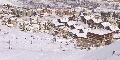
Winter in the village of faraya
Faraya (Arabic: فاريا) is a village and municipality in the Keserwan District of the Mount Lebanon Governorate, Lebanon. It is located 46 kilometers north of Beirut. Its average elevation is 1,850 meters above sea level and its total land area is 870 hectares. Faraya's inhabitants are predominantly Maronite Christians.
Contents
- Winter in the village of faraya
- Map of Faraiya Lebanon
- Lebanon byblos lady of lebanon beirut raouche faraya jounieh
- Geography
- Climate
- References
Map of Faraiya, Lebanon
Lebanon byblos lady of lebanon beirut raouche faraya jounieh
Geography
The name "Faraya" stands for "The land of fruits and vegetables" in Phoenician due to its soil fertility. Faraya is located in the Keserwan District in Lebanon, 42 km away from Beirut, and 20 km away from Jounieh. Faraya has an altitude ranging from 1600 m to 2300 m. The road to Faraya from the coastal highway passes through Ajaltoun, Ashqout, Faytroun, Mairouba, Hrajel.
In 2007, the Chabrouh Dam was inaugurated creating one of the highest reservoirs in the Middle-east region, but as a result, flooded more than three quarter of the orchards. The ski slopes are today the preferred destination for the region's visitors
Climate
In winter, Faraya has a cold climate with snow accumulations that can reach more than 1.5 metres (5 ft) and temperature drops to −6 °C (21 °F) or lower in winter. In summer temperature can reach over 30 °C (86 °F) in July and August.