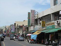
Country Taiwan Divisions List
26 villages Population 34,744 (Dec 2014) Local time Thursday 6:52 PM | County Changhua Website 芳苑鄉公所 (Chinese) Province Taiwan Province | |
 | ||
Weather 18°C, Wind N at 10 km/h, 79% Humidity | ||
Fangyuan Township (Chinese: 芳苑鄉; pinyin: Fāngyuàn Xiāng) is a rural township in Changhua County, Taiwan.
Contents
- Map of Fangyuan Township Changhua County Taiwan 528
- History
- Geography
- Administrative divisions
- Tourist attractions
- References
Map of Fangyuan Township, Changhua County, Taiwan 528
History
People have been immigrated from Fujian to the area since around 380 years ago where they practiced fishing and traded with people in Fujian. The area was then known as Fanzaiwa. The place was then renamed Shashan Village during the Japanese rule of Taiwan because of the sand dunes of the area. After the handover of Taiwan from Japan to the Republic of China in 1945, it became part of Taichung County. It was later renamed as Fangyuan Township and became part of Changhua County.
Geography
Fangyuan has been assigned the postal code 528. With a total area of 91.38 square kilometres (35.28 sq mi), the township is the second largest in Changhua County after Erlin Township. As of January 2017, there were 33,991 people in 10,129 households. The population density was 372 inhabitants per square kilometre (960/sq mi).
Administrative divisions
The township comprises 26 villages: Boai, Caohu, Dingbu, Fangyuan, Fangzhong, Furong, Hanbao, Heping, Houliao, Jianping, Lunjiao, Luping, Lushang, Minsheng, Renai, Sancheng, Sange, Wanggong, Wenjin, Wujun, Xinbao, Xingren, Xinjie, Xinsheng, Xinyi and Yongxing.
