
 | ||
The Eurasia Canal (Russian: Канал "Евразия", Kanal "Evraziya") is a proposed 700-kilometre-long (430 mi) canal connecting the Caspian Sea to the Black Sea along the Kuma-Manych Depression. Currently, a chain of lakes and reservoirs and the shallow irrigation Kuma-Manych Canal are found along this route.
Contents
The canal is intended to provide a shorter route for shipping than the existing Volga–Don Canal system of waterways; it would also require fewer locks (or lower-rise locks) than the Volga-Don route.
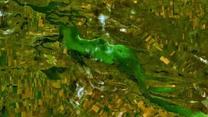
Manych Ship Canal is the existing canal system that would be the likely route for the Eurasian Canal.
Potential shipping route
The route of the canal, as usually proposed, would follow the thalweg (the lowest-ground line) of the Kuma-Manych Depression. From the Caspian Sea westward, the canal route would follow:
Locks
As the highest point of this route is only 27 meters above the level of the Sea of Azov and 54 m above that of the Caspian Sea, the preliminary design presented by the Hydraulic Facilities Safety Expert Center "GIDROTEKHEXPERTIZA" (Экспертный центр по безопасности гидротехнических сооружений "Гидротехэкспертиза") proposes the construction of three to four low-rise ship locks on the western slope and three mid-rise or six low-rise locks on the eastern slope. The option involving the construction of six low-rise locks on the eastern slope of the watershed can significantly reduce the volume of earthwork and lower by one-third the need for freshwater, which is precalculated as approximately 1.5 cubic km.
This compares favorably with the 13 locks of the existing Volga-Don Canal, where ships use nine locks to rise 88 m from the Volga to the canal's highest point, and then four more locks to descend 44 m to the Don's Tsimlyansk Reservoir.
Water supply
The Kuma-Manych depression area is quite arid, with annual precipitation no more than 400 mm (in the western section) and 200 mm (in the eastern section). To operate a shipping canal with locks, a significant additional supply of freshwater is necessary. Three options for its provision are being considered:
Supplying the Manych Waterway with freshwater from the Volga using the first or second option can compensate the Sea of Azov for the volume of freshwater that is now lost by the Don River to the locks of the Volga-Don Ship Canal.
History
The Soviet government decided to construct the Manych Waterway connecting the Black and Caspian Seas via the Kuma-Manych Depression in May 1932. In the same year construction started in the West Manych River Valley. According to the 1936 construction project, the shipping route consisted of three sections. The first, western, section from the Don River to the Chogray Reservoir on the East Manych, 448 km long, was planned as a cascade of reservoirs; the second section – from the Chogray Dam to the Kuma River – was to be built as a canal with a water depth of 3 m, bottom width of 67 m, and length of 73 km. The third, eastern, section, 150 km long, was intended as a free-flow navigable and irrigation canal (along the lower course of the Kuma) reaching a port on the Caspian coast. Of these three sections, only the first was ever built.
By 1941, the cascade of dams on the West Manych was completed. It created three reservoirs, in the following (east to west) order: Proletarsk (Proletarskoye) Reservoir (Пролетарское водохранилище), 150 km long, Vesyolovsk (Vesyolovskoe) Reservoir (Весёловское водохранилище), 100 km long, and Ust'-Manych (Ust'-Manychskoye) Reservoir (Усть-Манычское водохранилище), 62 km long. The uppermost reservoir of the cascade, the Proletarskoye, is in fact connected with the source of the Western Manych, Lake Manych-Gudilo, the Proletarsk dam raising the water level in the lake. This system of reservoirs and ship locks creates the so-called Manych Waterway, 329 km long but only 1.3 m deep. It is still used for shipping, but on a very minor scale.
With the outbreak of the Second World War further construction of the Manych Ship Canal was suspended. After the war, destroyed or damaged dams and locks of the shipping canal were reconstructed, but the plans for continuing the construction further eastward were canceled, since the much deeper Volga-Don Shipping Canal was built instead, and the existing demands for freight transport did not justify a second canal between the Caspian and the Black/Azov Sea basins.
Further east, on the East Manych River (which flows east), the Chogray Reservoir, 48.8 km long, was constructed in 1969-1973, but at that time the focus was on irrigation, not shipping.
Recent developments
The Russian government's interest in improvement of the waterways between the Caspian basin and that of the Azov and Black Seas - which may or may not involve the Eurasia Canal route - is due to the increasing volume of cargo traffic between the Volga-Caspian basin and European countries, as well as the inadequacy of existing facilities on the Volga-Don Canal for handling the expected cargo flows. The proponents of the project refer to a study of freight shipping in southern Russia by the Central Research Institute of Economy and Water Transport Exploitation (Russian: Центральный научно-исследовательский институт экономики и эксплуатации водного транспорта (ЦНИИЭВТ), TsNIIEVT), a research center of Russia's Ministry of Transport. This study predicts significant growth in the demand for freight transportation, in particular for liquid cargoes, between the Caspian region and the ports of southern and central Europe. The study also suggests that a significant amount of cargo shipped between the Asian countries and western Europe can be redirected to the canal as well.
On June 15, 2007, at the 17th Foreign Investors’ Council Meeting in Ust-Kamenogorsk, President Nursultan Nazarbayev of Kazakhstan proposed the Eurasia Canal project to build a canal connecting the Caspian and Black Seas. The project was estimated to cost US$6 billion and take 10 years to complete.
If built, the nearly 700 km (430 mi) Eurasia Canal would be four times longer than the Suez Canal and eight times longer than the Panama Canal. President Nazarbayev stated that the canal would make Kazakhstan a maritime power and benefit many other Central Asian nations as well. Russia has proposed an alternative plan to upgrade the existing Volga-Don Canal.
In June 2009 the President of Kalmykia, Kirsan Ilyumzhinov, signed a protocol of intent with the Chinese SINOHYDRO Corporation about cooperating in the construction of the Manych Ship Canal - Eurasia Canal
The most probable technical parameters of the Eurasia Canal are: 6.5 m depth, 110 m width and more than 75 million tons per year of traffic capacity. The canal is envisaged for the passage of vessels with a freight-carrying capacity up to 10,000 tons .