
Admin. region Oberpfalz Elevation 390-596 m (−1,565 ft) Population 1,443 (31 Dec 2008) Postal code 92268 | Area 21.69 km² Local time Wednesday 6:13 PM | |
 | ||
Municipal assoc. Neukirchen bei Sulzbach-Rosenberg Weather 6°C, Wind S at 13 km/h, 70% Humidity | ||
Etzelwang is a municipality in the district of Amberg-Sulzbach in Bavaria in Germany.
Contents
Map of Etzelwang, Germany
History
Etzelwang has existed as a parish since the second half of the 11th century. However, the present municipality of Etzelwang was not created until the Bavarian administrative reforms of 1972 to 1975. It was created from the political units of Neidstein, Kirchenreinbach, and Schmidtstadt.
Name
Etzel comes from the same root as Heinrich or English Henry. It is not certain which Heinrich gave his name to the parish and subsequently to the municipality. It is possible that it refers to Holy Roman Emperor Heinrich II, who founded the bishopric of Bamberg, to which the parish belonged.
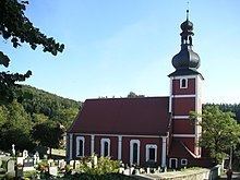
Sights
Places of interest in Etzelwang include the following:
References
Etzelwang Wikipedia(Text) CC BY-SA